Fires in Michoacán State from MODIS series (2015-2022) and their relation with climate
DOI:
https://doi.org/10.29298/rmcf.v15i84.1406Keywords:
agricultural burning, dry tropical forest, precipitation, temperate forest, temperature, time seriesAbstract
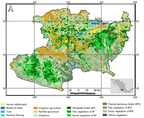
Fires affect more natural surfaces than any other disturbance factor on the planet. They result from the interaction of fuel, dry environmental conditions, and an ignition source. In the state of Michoacán conditions are conducive for the annual occurrence of numerous fires. Remote sensing offers global, consistent and objective information on fires, with the generation of series of burned areas, such as the 500m MCD64A1 generated from MODIS data. The objective of this work was to analyze this series to know the fires that occurred in the entity between 2015 and 2022, considering vegetation covers affected (INEGI Series VII) precipitation and temperature. An average of 3 340.87 pixels with fires were recorded annually; 2021, during confinement due to the Covid-19 pandemic, was the year with the most fires (5 269 pixels) and 2022 with the fewest (2 398). The fires are concentrated in the driest and hottest months, mainly May (1551.00 pixels on average) and April (958.38 pixels); the highest number was recorded in April 2021 (2 347 pixels), and the second month with the most detections was May 2020 (2 094 pixels). Most events are associated with agricultural burning (48.41%), mainly in irrigated land, in spring and winter. Forest fires significantly affect temperate forests and associated secondary vegetation (32.85%); in tropical deciduous forest areas (17.14%), fires occur mostly in secondary vegetation. In years with an early onset of rains (2015 and 2018), fewer fires accumulated.
Downloads
References
Bravo-Espinosa, M., M. E. Mendoza, T. Carlón A., L. Medina, J. T. Sáenz-Reyes and R. Páez. 2014. Effects of converting forest to avocado orchards on topsoil properties in the Trans-Mexican volcanic system, Mexico. Land Degradation & Development 25(5):452-467. Doi: 10.1002/ldr.2163. DOI: https://doi.org/10.1002/ldr.2163
Champo J., O., M. D. Uribe S. y M. L. España B. 2023. Validación comparativa de detección de áreas quemadas PROBA-V/MODIS/Sentinel-2 en Michoacán, México (2015-2020). Investigaciones Geográficas 112:e60774. Doi: 10.14350/rig.60774. DOI: https://doi.org/10.14350/rig.60774
Chávez-Ortiz, P. y J. A. Morón-Cruz. 2023. Efectos de la pandemia por COVID-19 en la contaminación ambiental. In: Oyama, K. y F. García-Oliva (Coords.). La década COVID en México: los desafíos de la pandemia desde las ciencias sociales y las humanidades. Tomo 14: Ecología, medio ambiente y sustentabilidad. Escuela Nacional de Estudios Superiores Unidad Morelia de la Universidad Nacional Autónoma de México. Coyoacán, Cd. Mx., México. pp. 343-365. https://decadacovid.humanidades.unam.mx/wp-content/uploads/DCM_tomo-14_ecolog-medio-ambiente-sustentabilidad.pdf. (6 de diciembre de 2023).
Chuvieco, E., F. Mouillot, G. R. van der Werf, J. San Miguel, … and L. Giglio. 2019. Historical background and current developments for mapping burned area from satellite Earth observation. Remote Sensing of Environment 225:45-64. Doi: 10.1016/j.rse.2019.02.013. DOI: https://doi.org/10.1016/j.rse.2019.02.013
Comisión Nacional Forestal (Conafor). 2024. Historial de incendios forestales. https://monitor_incendios.cnf.gob.mx/incendios-graficos-animados-barra. (12 de mayo de 2024).
Durán C., V. y F. Sevilla P. (Coords.). 2003. Atlas geográfico del Estado de Michoacán. Secretaría de Educación del Estado de Michoacán, Universidad Michoacana de San Nicolás de Hidalgo y EDDISSA. Morelia, Mich., México. 308 p.
Farfán G., M., A. Flamenco S., C. R. Rodríguez P., L. Rodrigues de Sousa S., I. González G. y Y. Gao. 2020. Cartografía de la probabilidad de ocurrencia a incendios forestales para el estado de Guanajuato: Una aproximación antrópica de sus fuentes de ignición. Acta Universitaria 30:1-15. Doi: 10.15174/au.2020.2953. DOI: https://doi.org/10.15174/au.2020.2953
Galván, L. and V. Magaña. 2020. Forest fires in Mexico: An approach to estimate fire probabilities. International Journal of Wildland Fire 29(9):753-763. Doi: 10.1071/WF19057. DOI: https://doi.org/10.1071/WF19057
Giglio, L., L. Boschetti, D. P. Roy, M. L. Humber and C. O. Justice. 2018. The Collection 6 MODIS burned area mapping algorithm and product. Remote Sensing of Environment 217:72-85. Doi: 10.1016/j.rse.2018.08.005. DOI: https://doi.org/10.1016/j.rse.2018.08.005
Giglio, L., L. Boschetti, D. Roy, A. A. Hoffmann, M. Humber and J. V. Hall. 2020. Collection 6 MODIS Burned area product user´s guide. Version 1.3. National Aeronautics and Space Administration (NASA). Washington, D. C., United States of America. 34 p. https://lpdaac.usgs.gov/documents/875/MCD64_User_Guide_V6.pdf. (6 de diciembre de 2023).
Giglio, L., W. Schroeder, J. V. Hall and C. O. Justice. 2021. MODIS Collection 6 and Collection 6.1 Active fire product user´s guide. Version 1.0. National Aeronautics and Space Administration (NASA). Washington, D. C., United States of America. 64 p. https://modis-fire.umd.edu/files/MODIS_C6_C6.1_Fire_User_Guide_1.0.pdf. (27 de marzo de 2023).
González G., I., M. Farfán G., L. M. Morales M., D. R. Pérez S., J. J. Garza S. y A. Medina P. 2023. Índices y modelos para la predicción de la ocurrencia de incendios forestales: una revisión para México. Revista Geográfica de América Central 2(71):193-219. Doi: 10.15359/rgac.71-2.7. DOI: https://doi.org/10.15359/rgac.71-2.7
González-Gutiérrez, I., J. F. Mas-Caussel, L. M. Morales-Manilla and K. A. Oceguera-Salazar. 2020. Thematic accuracy of hotspots and wildfires in Michoacán, Mexico. Revista Chapingo Serie Ciencias Forestales y del Ambiente 26(1):17-35. Doi: 10.5154/r.rchscfa.2019.01.011. DOI: https://doi.org/10.5154/r.rchscfa.2019.01.011
Instituto Nacional de Estadística y Geografía (Inegi). 2019. Carta de uso de suelo y vegetación de México, Serie VII, Escala 1:250 000. Inegi. https://www.inegi.org.mx/temas/usosuelo/#Descargas. (12 de mayo de 2024).
Jardel P., E. J., D. Pérez S., E. Alvarado y J. E. Morfín R. 2014. Principios y criterios para el manejo del fuego en ecosistemas forestales: guía de campo. Comisión Nacional Forestal (Conafor). Zapopan, Jal., México. 59 p. https://www.researchgate.net/publication/288827174_Principios_y_criterios_para_el_manejo_del_fuego_en_ecosistemas_forestales. (6 de diciembre de 2023).
Jones, M. W., J. T. Abatzoglou, S. Veraverbeke, N. Andela, … and C. Le Quéré. 2022. Global and regional trends and drivers of fire under climate change. Reviews of Geophysics 60(3):e2020RG000726. Doi: 10.1029/2020RG000726. DOI: https://doi.org/10.1029/2020RG000726
Justice, C., L. Giglio, L. Boschetti, D. Roy, … and Y. Kaufman. 2006. Algorithm technical background document. MODIS fire products. National Aeronautics and Space Administration. Washington, D. C., United States of America. 34 p. https://modis.gsfc.nasa.gov/data/atbd/atbd_mod14.pdf. (10 de junio de 2023).
Llorens, R., J. A. Sobrino, C. Fernández, J. M. Fernández-Alonso and J. A. Vega. 2021. A methodology to estimate forest fires burned areas and burn severity degrees using Sentinel-2 data. Application to the October 2017 fires in the Iberian Peninsula. International Journal of Applied Earth Observation and Geoinformation 95:102243. Doi: 10.1016/j.jag.2020.102243. DOI: https://doi.org/10.1016/j.jag.2020.102243
MacCarthy, J., J. Richter, S. Tyukavina, M. Weisse and N. Harris. 2023. The Latest Data Confirms: Forest Fires Are Getting Worse. https://www.wri.org/insights/global-trends-forest-fires. (6 de diciembre de 2023).
Manzo D., L. de L. 2016. Incendios forestales de gran relevancia: algoritmos y sensor MODIS para su detección y monitoreo. In: Moncada M., O. y Á. López L. (Coords.). Geografía de México. Una reflexión espacial contemporánea. Instituto de Geografía de la Universidad Nacional Autónoma de México. Coyoacán, Cd. Mx., Mexico. pp. 334-349. http://www.publicaciones.igg.unam.mx/index.php/ig/catalog/book/105. (12 de mayo de 2024).
Neger, C., J. F. León-Cruz, L. Galicia S. y L. de L. Manzo-Delgado. 2022a. Dinámica espaciotemporal, causas y efectos de los megaincendios forestales en México. Madera y Bosques 28(2):1-21. Doi: 10.21829/myb.2022.2822453. DOI: https://doi.org/10.21829/myb.2022.2822453
Neger, C., L. de L. Manzo D. y L. Galicia S. 2022b. La investigación geográfica de los incendios forestales en México: una perspectiva bibliométrica y territorial. Investigaciones Geográficas 108:e60488. Doi: 10.14350/rig.60488. DOI: https://doi.org/10.14350/rig.60488
Olivares M., L. D. 2020. Regímenes de incendios y sus efectos en suelos forestales de la franja aguacatera. Tesis de Maestría en Ecología Integrativa. Instituto de Investigaciones sobre los Recursos Naturales. Universidad Michoacana de San Nicolás de Hidalgo. Morelia, Mich., México. 142 p.
Pompa-García, M., J. J. Camarero, D. A. Rodríguez-Trejo and D. J. Vega-Nieva. 2018. Drought and spatiotemporal variability of forest fires across Mexico. Chinese Geographical Science 28(1):25-37. Doi: 10.1007/s11769-017-0928-0. DOI: https://doi.org/10.1007/s11769-017-0928-0
Quantum Geographical Information System (QGIS). 2024. QGIS 3.22. Santa Cruz, CA, United States of America. QGIS. https://www.qgis.org/en/site/forusers/download.html. (12 de mayo de 2024).
Rui, H. and H. Beaudoing. 2022. README Document for NASA GLDAS Version 2 Data Products. NASA Goddard Space Flight Center. Greenbelt, MD, United States of America. 34 p. https://hydro1.gesdisc.eosdis.nasa.gov/data/GLDAS/GLDAS_NOAH025_M.2.1/doc/README_GLDAS2.pdf. (4 de diciembre de 2023).
Rzedowski, J. 2006. Vegetación de México. Comisión Nacional para el Conocimiento y Uso de la Biodiversidad (Conabio). Tlalpan, D. F., México. 504 p.
Sentinel Application Platform (Snap). 2024. Copernicus Data Space Ecosystem (Snap v. 8.0). Paris, Par., France. European Space Agency. https://step.esa.int/main/download/snap-download/. (12 de mayo de 2024).
Szpakowski, D. M. and J. L. R. Jensen. 2019. A review of the applications of remote sensing in fire ecology. Remote Sensing 11(22):2638. Doi: 10.3390/rs11222638. DOI: https://doi.org/10.3390/rs11222638
Villar-Hernández, B. de J., S. Pérez-Elizalde, D. A. Rodríguez-Trejo and P. Pérez-Rodríguez. 2022. Spatio-temporal analysis of wildfires occurrence in the Mexican State of Oaxaca. Revista Mexicana de Ciencias Forestales 13(74):120-144. Doi: 10.29298/rmcf.v13i74.1274. DOI: https://doi.org/10.29298/rmcf.v13i74.1274
Zúñiga-Vásquez, J. M., D. Cisneros-González, M. Pompa-García, D. A. Rodríguez-Trejo and G. Pérez-Verdín. 2017. Spatial modeling of forest fires in Mexico: an integration of two data sources. Bosque 38(3):563-574. Doi: 10.4067/S0717-92002017000300014. DOI: https://doi.org/10.4067/S0717-92002017000300014
Published
How to Cite
Issue
Section
License
Copyright (c) 2024 Revista Mexicana de Ciencias Forestales

This work is licensed under a Creative Commons Attribution-NonCommercial 4.0 International License.
The authors who publish in Revista Mexicana de Ciencias Forestales accept the following conditions:
In accordance with copyright laws, Revista Mexicana de Ciencias Forestales recognizes and respects the authors’ moral right and ownership of property rights which will be transferred to the journal for dissemination in open access.
All the texts published by Revista Mexicana de Ciencias Forestales –with no exception– are distributed under a Creative Commons License Attribution-NonCommercial 4.0 International (CC BY-NC 4.0), which allows third parties to use the publication as long as the work’s authorship and its first publication in this journal are mentioned
The author(s) can enter into independent and additional contractual agreements for the nonexclusive distribution of the version of the article published in Revista Mexicana de Ciencias Forestales (for example, include it into an institutional repository or publish it in a book) as long as it is clearly and explicitly indicated that the work was published for the first time in Revista Mexicana de Ciencias Forestales.
For all the above, the authors shall send the form of Letter-transfer of Property Rights for the first publication duly filled in and signed by the author(s). This form must be sent as a PDF file to: ciencia.forestal2@inifap.gob.mx
This work is licensed under a Creative Commons Attribution-Noncommercial 4.0 International license.