Temporary analysis of land use in a Ramsar site (No. 1981) in central Nuevo León
DOI:
https://doi.org/10.29298/rmcf.v14i79.1356Keywords:
Agricultura, cambio de uso de suelo, conservación, humedal, México, RamsarAbstract
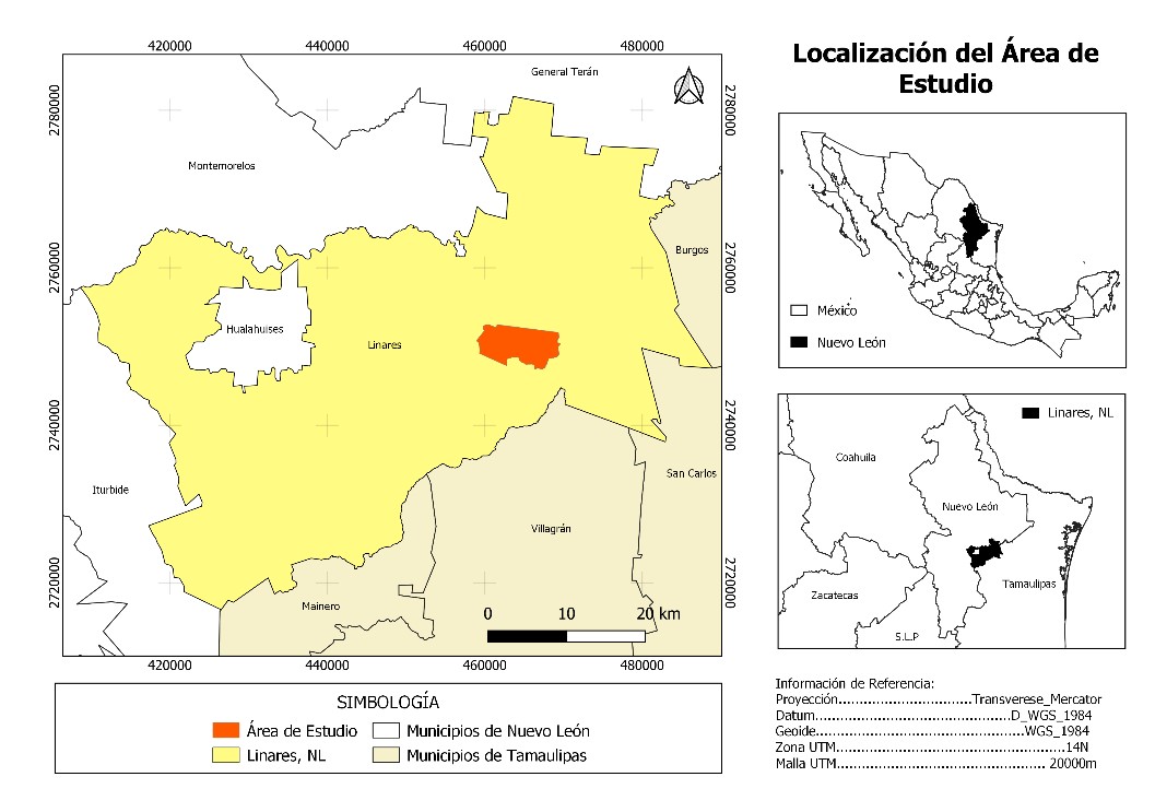
The ecosystem services provided by wetlands are central to the sustainability of societies through their contribution to food supply and climate regulation. The gradual deterioration of these ecosystems exacerbates the environmental crisis and the deterioration of water quality. Ramsar Sites were created for the protection of the world's wetlands, with the aim of preserving the integrity and maintenance of their biological character. This study presents the situation of Ramsar Site No. 1981 which is in north-eastern Mexico, using satellite images and land use maps, land use change is accounted for a period of 44 years analysed in three temporal snapshots: 1975, 2003 and 2019. The flooded area decreased by 84 %, scrubland decreased by 36 % and agricultural area increased by 547 %, and grassland by 284 %. The area increased at the expense of floodplain cover, possibly caused by prolonged periods of drought over the last few decades. It is essential to recognise that Mexico has not legislated specifically for the protection of Wetlands, therefore decree a system of Ramsar is not enough to stop or reverse the processes of environmental degradation. It is necessary to improve the management of existing laws and develop an adaptive management plan subject to hydrological changes due climate change, inadequate watershed management and lack of natural cover.
Downloads
References
Referencias
Agaton, C. B. and P. M. C. Guila. 2023. Ecosystem services valuation of constructed wetland as a nature-based solution to wastewater treatment. Earth 4(1):78-92. Doi: 10.3390/earth4010006. DOI: https://doi.org/10.3390/earth4010006
Amenu, B. T and G. S. Mamo. 2018. Review on wetland ecosystem destruction. International Journal of Scientific Research in Civil Engineering 2(2):5-15. https://ijsrce.com/IJSRCE182202. (20 de julio de 2021).
Ballut-Dajud, G. A., L. C. Sandoval H., G. Fernández-Lambert, J. L. Marín-Muñiz, M. C. López M. and E. A. Betanzo-Torres. 2022. Factors affecting wetland loss: a review. Land 11(3):434. Doi: 10.3390/land11030434. DOI: https://doi.org/10.3390/land11030434
Benítez G., M. C. 1997. Contribución a la caracterización ecológica y socioeconómica de la región "Baño de San Ignacio". Tesis de Maestría en Ciencias Forestales. Facultad de Ciencias Forestales, Universidad Autónoma de Nuevo León. Linares, NL, México. 136 p.
Briggs, M. K., E. A. Lozano-Cavazos, H. M. Poulos, J. Ochoa-Espinoza and J. A. Rodríguez-Pineda. 2020. The Chihuahuan Desert: A binational conservation response to protect a global treasure. In: Goldstein, M. I. and D. A. DellaSala (Edits.). Encyclopedia of the World´s Biomes. Elsevier Inc. Amsterdam, NH, Netherlands. pp. 126-138. DOI: https://doi.org/10.1016/B978-0-12-409548-9.11966-9
Cantú A., C. 2009. Ficha Informativa de los Humedales de Ramsar (FIR)-Versión 2009-2012: Baño de San Ignacio. Facultad de Ciencias Forestales y Universidad Autónoma de Nuevo León. Linares, NL, México. 23 p. https://rsis.ramsar.org/RISapp/files/RISrep/MX1981RIS.pdf. (1 de septiembre de 2021).
Cantú S., I. y H. González R. 2002. Propiedades hidrológicas del dosel de los bosques de pino-encino en el noreste de México. Ciencia UANL 5(1):72-77. http://eprints.uanl.mx/972/1/propied_hidrol.pdf. (8 de febrero 2023).
Cantú, C., R. Guerra, F. González y L. Rocha. 2001. Programa de Manejo del Área Natural Protegida Baño de San Ignacio. Gobierno del Estado de Nuevo León y Universidad Autónoma de Nuevo León. Monterrey, NL, México. 145 p. https://archive.org/details/programa-de-manejo-anp-bsi/. (20 de julio de 2021).
Castellanos-Navarrete, A. 2021. Oil palm dispersal into protected wetlands: Human-environment dichotomies and the limits to governance in south Mexico. Land Use Policy 103:1-13. Doi: 10.1016/j.landusepol.2021.105304. DOI: https://doi.org/10.1016/j.landusepol.2021.105304
Centro de Estudios para el Desarrollo Rural Sustentable y la Soberanía Alimentaria (CEDRSSA). 2021. Importancia, Protección, Conservación de los Humedales. CEDRSSA y Cámara de Diputados LXV Legislatura. Venustiano Carranza, Cd. Mx., México. 23 p. http://www.cedrssa.gob.mx/files/10/89Importancia,%20protecci%C3%B3n,%20conservaci%C3%B3n%20de%20los%20humedales.pdf. (29 de octubre 2021).
Chacon-Baca, E., L. Alba-Aldave, S. Angeles y C. Cantú-Ayala. 2015. Tapetes microbianos recientes en el manantial hidrotermal de Baño San Ignacio, Linares, Nuevo León. Boletín de la Sociedad Geológica Mexicana 67(3):387-400. Doi: 10.18268/BSGM2015v67n3a3. DOI: https://doi.org/10.18268/BSGM2015v67n3a3
Clark Labs. 2022. TerrSet 2020 Software Features (Versión 17.0). Worcester, MA, United States of America. Universidad Clark. http://www.clarklabs.org. (30 de mayo 2023).
Clarke, B., A. K. Thet, H. Sandhu and S. Dittmann. 2021. Integrating cultural ecosystem services valuation into coastal wetlands restoration: A case of study from South Australia. Environmental Science and Policy 116:220-229. Doi: 10.1016/j.envsci.2020.11.014. DOI: https://doi.org/10.1016/j.envsci.2020.11.014
Convención de Ramsar sobre los Humedales. 2018. Perspectiva mundial sobre los humedales: Estado de los humedales del mundo y sus servicios a las personas. Secretaría de la Convención Ramsar. Gland, VD, Suiza. 84 p. https://www.ramsar.org/sites/default/files/documents/library/gwo_s.pdf. (4 de octubre de 2021).
Cowardin, L. M., V. Carter, F. C. Golet and E. T. LaRoe. 1979. Classification of wetlands and deepwater habitats of the United States. United States Department of the Interior and Fish and Wildlife Service. Washington, DC, United States of America. 131 p. DOI: https://doi.org/10.5962/bhl.title.4108
Eastman, J. R. 2012. IDRISI Selva, Guía para SIG y procesamiento de imágenes. Universidad Clark. Worcester, MA, Estados Unidos de América. 321 p.
eBird. 2023. Grulla gris. The Cornell Lab of Ornithology. https://ebird.org/species/sancra?siteLanguage=es_MX. (20 de febrero de 2023).
Food and Agriculture Organization of the United Nations (FAO). 2022. The state of world fisheries and aquaculture 2022. Towards Blue Transformation. FAO. Rome, RM, Italy. 236 p.
Gabrielli, S., M. Spagnolo and L. De Siena. 2020. Geomorphology and surface geology of Mount St. Helens volcano. Journal of Maps 16(2):585-594. Doi: 10.1080/17445647.2020.1790048. DOI: https://doi.org/10.1080/17445647.2020.1790048
Gupta, R. and L. K. Sharma. 2020. Efficacy of spatial land change modeler as a forecasting indicator for anthropogenic change dynamics over five decades: A case study of Shoolpaneshwar Wildlife Sanctuary, Gujarat, India. Ecological Indicators 112(274):106171. Doi: 10.1016/j.ecolind.2020.106171. DOI: https://doi.org/10.1016/j.ecolind.2020.106171
Hausner, V. H., G. Brown and E. Lægreid. 2015. Effects of land tenure and protected areas on ecosystem services and land use preferences in Norway. Land Use Policy 49:446-461. Doi: 10.1016/j.landusepol.2015.08.018. DOI: https://doi.org/10.1016/j.landusepol.2015.08.018
Humacata, L. 2019. Análisis espacial de los cambios de usos del suelo. Aplicación con Sistemas de Información Geográfica. Revista Cartográfica (98):239-257. Doi: 10.35424/rcarto.i98.149. DOI: https://doi.org/10.35424/rcarto.i98.149
Landgrave, R. y P. Moreno-Casasola. 2012. Evaluación cuantitativa de la pérdida de humedales en México. Investigación Ambiental 4(1):19-35. https://biblat.unam.mx/es/revista/investigacion-ambiental-ciencia-y-politica-publica/articulo/evaluacion-cuantitativa-de-la-perdida-de-humedales-en-mexico. (29 de octubre 2021).
Lozano-Vilano, M. L., A. J. Contreras-Balderas, G. Ruiz-Campos and M. E. García-Ramírez. 2021. Current conservation status of some freshwater species and their habitats in México. In: Propst, D. L., J. E. Williams, K. R. Bestgen and C. W. Hoagstrom (Edits). Standing between life and extinction: Ethics and ecology of conserving aquatic species in North American Deserts. The University of Chicago Press. Chicago, IL, United States of America. pp.:79-88. DOI: https://doi.org/10.7208/chicago/9780226694504.003.0005
Maass, M., E. Jardel, A. Martínez-Yrizar, L. Calderón, … y M. Equihua. 2010. Las áreas naturales protegidas y la investigación ecológica de largo plazo en México. Ecosistemas Revista Científica y Técnica de Ecología y Medio Ambiente 19(2):69-83. https://www.revistaecosistemas.net/index.php/ecosistemas/article/view/47. (3 de marzo 2023).
Mauerhofer, V., R. E. Kim and C. Stevens. 2015. When implementation works: A comparison of Ramsar Convention implementation in different continents. Environmental Science and Policy 51:95-105. Doi: 10.1016/j.envsci.2015.03.016. DOI: https://doi.org/10.1016/j.envsci.2015.03.016
McCauley, L. A. and D. G. Jenkins. 2005. GIS-based estimates of former and current depressional wetlands in an agricultural landscape. Ecological Applications 15(4):1199-1208. https://stars.library.ucf.edu/facultybib2000/5468. (3 de marzo 2023). DOI: https://doi.org/10.1890/04-0647
Mendenhall, C. D. and A. M. Wrona. 2018. Improving tree cover estimates for fine-scale landscape ecology. Landscape Ecology 33:1691-1696. Doi: 10.1007/s10980-018-0704-2. DOI: https://doi.org/10.1007/s10980-018-0704-2
Merlín-Uribe, Y., A. Contreras-Hernández, M. Astier-Calderón, O. P. Jensen, R. Zaragoza and L. Zambrano. 2012. Urban expansion into a protected natural area in Mexico City: alternative management scenarios. Journal of Environmental Planning and Management 56(3):1-14. Doi: 10.1080/09640568.2012.683686. DOI: https://doi.org/10.1080/09640568.2012.683686
Natural History Museum. 2021. Past (Version 4.12). Oslo, O, Norway. University of Oslo. https://www.nhm.uio.no/english/research/resources/past/. (14 de octubre de 2021).
OpenStreetMap. 2021. OpenStreetMap (Área Natural Protegida Baño de San Ignacio). Fundación OpenStreetMap. https://www.openstreetmap.org/#map=13/24.8594/-99.3478. (1 de agosto de 2021).
Pedersen, E., S. E. B. Weisner and M. Johansson. 2019. Wetland areas´ direct contributions to residents´ well-being entitle them to high cultural ecosystem values. Science of the Total Environment 646:1315-1326. Doi: 10.1016/j.scitotenv.2018.07.236. DOI: https://doi.org/10.1016/j.scitotenv.2018.07.236
Pérez A., X. J. 2017. Estudio geofísico para la determinación de la estructura geológica en los alrededores del Baño San Ignacio, Linares, Nuevo León. Tesis de Maestría en Ciencias Geológicas. Facultad de Ciencias de la Tierra, Universidad Autónoma de Nuevo León. Linares, NL, México. 101 p.
QGIS Development Team. 2021. QGIS (Version 3.32.2). Geographic Information System. https://qgis.org. (5 de mayo de 2021).
Ramsar. 2023a. La Convención sobre los Humedales y su misión. https://www.ramsar.org/es/acerca-de/la-convencion-sobre-los-humedales-y-su-mision. (5 de febrero de 2023).
Ramsar. 2023b. México, la Convención sobre los Humedales. https://www.ramsar.org/es/humedal/mexico. (20 de febrero de 2023).
Ramsar. 2023c. Servicio de Información sobre Sitios Ramsar. https://rsis.ramsar.org/es. (27 de marzo 2023).
Rochgiyanti, M. and H. Susanto. 2017. Transformation of wetland local wisdom values on activities of Swamp Buffalo Breeding in Social Science Learning Practice. Advances in Social Science, Education and Humanities Research 147:272-276. Doi: 10.2991/icsse-17.2018.62. DOI: https://doi.org/10.2991/icsse-17.2018.62
Sarkar, P., M. Salami, Y. Githiora, R. Vieria, … and M. Padgurschi. 2020. A conceptual model to understand the drivers of changes in tropical wetlands: a comparative assessment in India and Brazil. Biota Neotropica 20:e20190913. Doi: 10.1590/1676-0611-BN-2019-0913. DOI: https://doi.org/10.1590/1676-0611-bn-2019-0913
Secretaría de Medio Ambiente y Recursos Naturales (Semarnat). 2018. ANP, corazón del patrimonio natural de México. https://www.gob.mx/semarnat/es/articulos/inedito-21-de-junio-articulo-central-anp-corazon-del-patrimonio-natural-de-mexico-mas-de-90-millones-de-has-resguardan-porciones-terrestres-acuaticas-e-insulares-de-importancia-para-la-conservacion-de-la-biodiversidad-desde-tiempos-remotos-ya-s?idiom=es#:~:text=Las%20ANP%20son%20zonas%20del,sujetas%20al%20r%C3%A9gimen%20previsto%20en. (2 de febrero de 2023).
Servicio Meteorológico Nacional. 2011. Normales Climatológicas, Nuevo León, 1951-1910, Estación 00019011 Cerro Prieto. Comisión Nacional del Agua. https://smn.conagua.gob.mx/tools/RESOURCES/Normales5110/NORMAL19011.TXT. (15 de octubre de 2021).

Published
How to Cite
Issue
Section
License
Copyright (c) 2023 Revista Mexicana de Ciencias Forestales

This work is licensed under a Creative Commons Attribution-NonCommercial 4.0 International License.
The authors who publish in Revista Mexicana de Ciencias Forestales accept the following conditions:
In accordance with copyright laws, Revista Mexicana de Ciencias Forestales recognizes and respects the authors’ moral right and ownership of property rights which will be transferred to the journal for dissemination in open access.
All the texts published by Revista Mexicana de Ciencias Forestales –with no exception– are distributed under a Creative Commons License Attribution-NonCommercial 4.0 International (CC BY-NC 4.0), which allows third parties to use the publication as long as the work’s authorship and its first publication in this journal are mentioned
The author(s) can enter into independent and additional contractual agreements for the nonexclusive distribution of the version of the article published in Revista Mexicana de Ciencias Forestales (for example, include it into an institutional repository or publish it in a book) as long as it is clearly and explicitly indicated that the work was published for the first time in Revista Mexicana de Ciencias Forestales.
For all the above, the authors shall send the form of Letter-transfer of Property Rights for the first publication duly filled in and signed by the author(s). This form must be sent as a PDF file to: ciencia.forestal2@inifap.gob.mx
This work is licensed under a Creative Commons Attribution-Noncommercial 4.0 International license.


