Land-use change and vegetation cover in the San Pedro Mártir River sub-basin, Tabasco state, Mexico
DOI:
https://doi.org/10.29298/rmcf.v17i94.1608Keywords:
multitemporal analysis, land-use change, vegetation cover, landscape dynamics, tropical regions, remote sensingAbstract
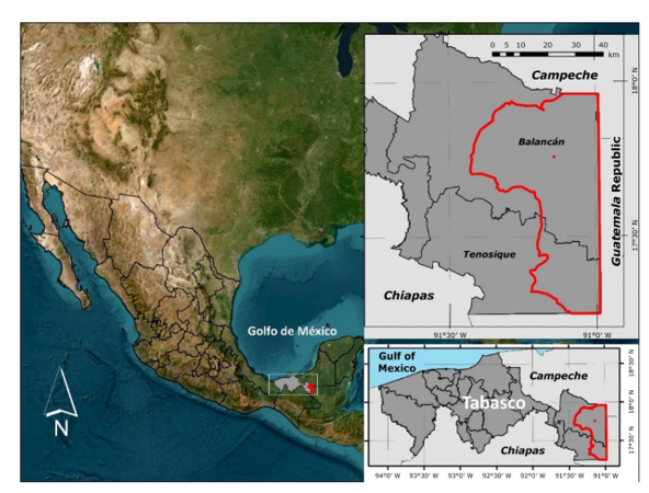
The aim of this study was to analyze the dynamics of land-use and vegetation cover change in the San Pedro Mártir River sub-basin, Tabasco state, Mexico, for the 1984-2024 period using remote sensing techniques and geographic information systems. Landsat images corresponding to the 1984, 2000 and 2024 years were classified into eight land-use and vegetation cover categories. Based on these classifications, surface areas, vegetation cover transitions and annual rates of change were estimated for two analysis periods. The results reveal a territorial transformation characterized by the consolidation of pastures as the dominant vegetation cover, increasing from 33.7 % of the surface area in 1984 to 45.4 % in 2024. Secondary vegetation exhibited highly dynamic behavior, with phases of loss and partial recovery, confirming its role as a transitional cover within recurrent land-use cycles. Flooded lowland forest and ecosystems associated with inundated environments highlight a net reduction toward the end of the analyzed period. From 2000 onward, the emergence and rapid expansion of forest plantations were identified, mainly over agricultural areas, pastures, and secondary vegetation, reaching 6.2 % of the territory in 2024. The identified change trajectories reflect a productive reconfiguration of the landscape characterized by structural simplification and fragmentation of forest cover. The study provides a spatial and temporal baseline for analyzing territorial dynamics in humid tropical regions.
Downloads
References
Agudelo-Hz, W. J., Castillo-Barrera, N. C., & Murcia-García, U. (2023). Scenarios of land use and land cover change in the Colombian Amazon to evaluate alternative post-conflict pathways. Scientific Reports, 13, Article 2152. https://doi.org/10.1038/s41598-023-29243-2 DOI: https://doi.org/10.1038/s41598-023-29243-2
Alarcón-Aguirre, G., Canahuire-Robles, R. R., Guevara-Duarez, F. M., Rodríguez-Achata, L., Gallegos-Chacón, L. E., & Garate-Quispe, J. (2021). Dinámica de la pérdida de bosques en el sureste de la Amazonia peruana. Ecosistemas, 30(2), Artículo 2175. https://doi.org/10.7818/ECOS.2175 DOI: https://doi.org/10.7818/ECOS.2175
Center for Geospatial Analytics. (2020). Land Change Modeler in TerrSet. Clark University. https://clarklabs.org/terrset/land-change-modeler/
Chan, K. K. Y., Ren, Z., Liu, Y., Song, H., Bai, Y., & Xu, B. (2025). Land cover change and fragmentation within China’s Ramsar sites. Remote Sensing, 17(5), Article 896. https://doi.org/10.3390/rs17050896 DOI: https://doi.org/10.3390/rs17050896
Congedo, L. (2023, October 8). Semi-Automatic Classification Plugin (Versión 8.01) [Software]. QGIS Development Team. https://plugins.qgis.org/plugins/SemiAutomaticClassificationPlugin/?utm_source=chatgpt.com#plugin-versions
Curtis, P. G., Slay, C. M., Harris, N. L., Tyukavina, A., & Hansen, M. C. (2018). Classifying drivers of global forest loss. Science, 361(6407), 1108-1111. https://doi.org/10.1126/science.aau3445 DOI: https://doi.org/10.1126/science.aau3445
Eastman, J. R. (2012). IDRISI Selva: Guide to GIS and image processing. Clark University. https://clarklabs.org/wp-content/uploads/2016/10/IDRISI-Selva-Spanish-Manual.pdf
Estacio, I., Basu, M., Sianipar, C. P. M., Onitsuka, K., & Hoshino, S. (2022). Dynamics of land cover transitions and agricultural abandonment in a mountainous agricultural landscape: Case of Ifugao rice terraces, Philippines. Landscape and Urban Planning, 222, Article 104394. https://doi.org/10.1016/j.landurbplan.2022.104394 DOI: https://doi.org/10.1016/j.landurbplan.2022.104394
Fagan, M. E., Kim, D.-H., Settle, W., Ferry, L., Drew, J., Carlson, H., Slaughter, J., Schaferbien, J., Tyukavina, A., Harris, N. L., Goldman, E., & Ordway, E. M. (2022). The expansion of tree plantations across tropical biomes. Nature Sustainability, 5, 681-688. https://www.nature.com/articles/s41893-022-00904-w DOI: https://doi.org/10.1038/s41893-022-00904-w
Gibbs, H. K., Ruesch, A. S., Achard, F., Clayton, M. K., Holmgren, P., Ramankutty, N., & Foley, J. A. (2010). Tropical forests were the primary sources of new agricultural land in the 1980s and 1990s. Proceedings of the National Academy of Sciences, 107(38), 16732-16737. https://doi.org/10.1073/pnas.0910275107 DOI: https://doi.org/10.1073/pnas.0910275107
Gobierno del Estado de Tabasco. (2002). Acuerdo en el que se declara Área Natural Protegida de Jurisdicción Estatal clasificada como Reserva Ecológica, en el municipio de Balancán, Tabasco y cuya denominación es «Cascadas de Reforma». Periódico Oficial del Estado de Tabasco [No. 17432]. https://tabasco.gob.mx/sites/default/files/users/sbstabasco/DRE-CR-Reserva%20Ecol%C3%B3gica%20Cascadas%20de%20Reforma.pdf
Gobierno del Estado de Tabasco. (2024, 15 de julio). El sector forestal en el Estado de Tabasco. Gobierno del Estado de Tabasco. https://tabasco.gob.mx/el-sector-forestal-en-el-estado-de-tabasco
Hansen, M. C., Potapov, P. V., Moore, R., Hancher, M., Turubanova, S. A., Tyukavina, A., Thau, D., Stehman, S. V., Goetz, S. J., Loveland, T. R., Kommareddy, A., Egorov, A., Chini, L., Justice, C. O., & Townshend, J. R. G. (2013). High-resolution global maps of 21st-century forest cover change. Science, 342(6160), 850-853. https://www.science.org/doi/10.1126/science.1244693 DOI: https://doi.org/10.1126/science.1244693
Hernández-Pérez, E., García-Franco, J. G., Vázquez, G., & Cantellano-de Rosas, E. (2022). Cambio de uso de suelo y fragmentación del paisaje en el centro de Veracruz, México (1989-2015). Madera y Bosques, 28(1), Artículo e2812294. https://doi.org/10.21829/myb.2022.2812294 DOI: https://doi.org/10.21829/myb.2022.2812294
Instituto Nacional de Estadística, Geografía e Informática. (1986). Síntesis geográfica, nomenclátor y anexo cartográfico del estado de Tabasco. Síntesis Geográfica de Tabasco. Instituto Nacional de Estadística, Geografía e Informática. https://www.inegi.org.mx/contenidos/productos/prod_serv/contenidos/espanol/bvinegi/productos/historicos/2104/702825221256/702825221256_1.pdf#[14,{%22name%22:%22Fit%22}
Instituto Nacional de Estadística y Geografía. (2021). SIATL v4, Simulador de Flujos de Agua de Cuencas Hidrográficas [Mapa interactivo]. Instituto Nacional de Estadística y Geografía. https://antares.inegi.org.mx/analisis/red_hidro/siatl/
Kotowska, M. M., Samhita, S., Hertel, D., Triadiati, T., Beyer, F., Allen, K., Link, R. M., & Leuschner, C. (2023). Consequences of tropical rainforest conversion to tree plantations on fine root dynamics and functional traits. Oikos, 2023(1), Article e08898. https://doi.org/10.1111/oik.08898 DOI: https://doi.org/10.1111/oik.08898
Manjarrez-Muñoz, B., Hernández-Daumás, S., De Jong, B., Nahed-Toral, J., de Dios-Vallejo, O. O., & Salvatierra-Zaba, E. B. (2007). Configuración territorial y perspectivas de ordenamiento de la ganadería bovina en los municipios de Balancán y Tenosique, Tabasco. Investigaciones Geográficas, Boletín del Instituto de Geografía, (64), 90-115. https://www.investigacionesgeograficas.unam.mx/index.php/rig/article/view/17968
Maza-Villalobos, S., Alvarado-Sosa, E., Arriaza-Rodríguez, A. D., Infante, F., & Castillo-Santiago, M. Á. (2023). Dinámica del uso de suelo y vegetación en paisajes altamente modificados por actividades agropecuarias en el sur de México. Botanical Sciences, 101(2), 374-386. https://doi.org/10.17129/botsci.3148 DOI: https://doi.org/10.17129/botsci.3148
Megia-Vera, H. J., Peralta-Carreta, C., Medrano-Pérez, O., Palomeque-De la Cruz, M. Á., Ramos-Reyes, R., & Galindo-Alcantara, A. (2025). Análisis de la cobertura y uso de suelo de la Cuenca Baja del Río Usumacinta mediante técnicas de teledetección. Terra Latinoamericana, 43, 1-15. https://doi.org/10.28940/terralatinoamericana.v43i.2075 DOI: https://doi.org/10.28940/terralatinoamericana.v43i.2075
Mello, A. L., Lezama, F., & Baeza, S. (2023). Patrones y controles regionales de la fragmentación de pastizales naturales en Uruguay. Ecosistemas, 32(2), Article 2534. https://doi.org/10.7818/ECOS.2534 DOI: https://doi.org/10.7818/ECOS.2534
Osorio-Olvera, L., Rioja-Nieto, R., Torres-Irineo, E., & Guerra-Martínez, F. (2023). Natural Protected Areas effect on the cover change rate of mangrove forests in the Yucatan Peninsula, Mexico. Wetlands, 43, Article 52. https://doi.org/10.1007/s13157-023-01697-0 DOI: https://doi.org/10.1007/s13157-023-01697-0
Palacio-Prieto, J. L., Sánchez-Salazar, M. T., Casado-Izquierdo, J. M., Propin-Frejomil, E., Delgado-Campos, J., Velázquez-Montes, A., Chias-Becerril, J., Ortiz-Álvarez, M. I., González-Sánchez, J., Negrete-Fernández, G., Gabriel-Morales, J., & Márquez-Huitzil, R. (Coord.). (2004). Indicadores para la caracterización y ordenamiento del territorio. Universidad Nacional Autónoma de México, Secretaría de Desarrollo Social, Secretaría de Medio Ambiente y Recursos Naturales e Instituto Nacional de Ecología. https://unidadesdepaisaje.unam.mx/sites/default/files/2022-06/Palacio%20et%20al%2C%202004_0.pdf
QGIS Development Team. (2024). QGIS Geographic Information System (Version 3.36) [Software]. QGIS Association. https://www.qgis.org/
Ramírez-García, A. R., Zavala-Cruz, J., Rincón-Ramírez, J. A., Guerrero-Peña, A., García-López, E., Sánchez-Hernández, R., Castillo-Acosta, O., Alfaro-Sánchez, G., & Ortiz-Pérez, M. A. (2022). Vegetation cover and land use change (1947-2019) in the region of Los Ríos, Tabasco, México. Revista Chapingo Serie Ciencias Forestales y del Ambiente, 28(3), 465-481. http://doi.org/10.5154/r.rchscfa.2022.01.001 DOI: https://doi.org/10.5154/r.rchscfa.2022.01.001
Ramos-Reyes, R., & Palomeque-de la Cruz, M. Á. (2023). Cambio de uso del suelo y escenarios prospectivos en el Estado de Tabasco (México). Anales de Geografía de la Universidad Complutense, 43(1), 185-209. https://doi.org/10.5209/aguc.85944 DOI: https://doi.org/10.5209/aguc.85944
Secretaría de Gobernación. (2008). DECRETO por el que se declara área natural protegida con la categoría de área de protección de flora y fauna, la región conocida como Cañón del Usumacinta, localizada en el Municipio de Tenosique, en el Estado de Tabasco. Diario Oficial de la Federación. https://www.dof.gob.mx/nota_detalle.php?codigo=5060691&fecha=22/09/2008#gsc.tab=0
Secretaría de Gobernación. (2023). DECRETO por el que se declara área natural protegida Wanha’, con el carácter de reserva de la biosfera, la superficie de 38,255-64-17.76 hectáreas, ubicada en los municipios de Balancán y Tenosique, estado de Tabasco. Diario Oficial de la Federación. https://www.dof.gob.mx/nota_detalle_popup.php?codigo=5700586
United States Geological Survey. (2024). EarthExplorer [Interactive compendium of maps]. United States Geological Survey. https://earthexplorer.usgs.gov/
Von Thaden, J. J., Laborde, J., Guevara, S., & Mokondoko-Delgadillo, P. (2020). Dinámica de los cambios en el uso del suelo y cobertura vegetal en la Reserva de la Biosfera Los Tuxtlas (2006-2016). Revista Mexicana de Biodiversidad, 91, Artículo e913190. https://doi.org/10.22201/ib.20078706e.2020.91.3190 DOI: https://doi.org/10.22201/ib.20078706e.2020.91.3190
Published
How to Cite
Issue
Section
License
Copyright (c) 2026 Revista Mexicana de Ciencias Forestales

This work is licensed under a Creative Commons Attribution-NonCommercial 4.0 International License.
The authors who publish in Revista Mexicana de Ciencias Forestales accept the following conditions:
In accordance with copyright laws, Revista Mexicana de Ciencias Forestales recognizes and respects the authors’ moral right and ownership of property rights which will be transferred to the journal for dissemination in open access.
All the texts published by Revista Mexicana de Ciencias Forestales –with no exception– are distributed under a Creative Commons License Attribution-NonCommercial 4.0 International (CC BY-NC 4.0), which allows third parties to use the publication as long as the work’s authorship and its first publication in this journal are mentioned
The author(s) can enter into independent and additional contractual agreements for the nonexclusive distribution of the version of the article published in Revista Mexicana de Ciencias Forestales (for example, include it into an institutional repository or publish it in a book) as long as it is clearly and explicitly indicated that the work was published for the first time in Revista Mexicana de Ciencias Forestales.
For all the above, the authors shall send the form of Letter-transfer of Property Rights for the first publication duly filled in and signed by the author(s). This form must be sent as a PDF file to: ciencia.forestal2@inifap.gob.mx
This work is licensed under a Creative Commons Attribution-Noncommercial 4.0 International license.