Análisis multitemporal mediante imágenes de alta resolución en un Matorral Espinoso Tamaulipeco
DOI:
https://doi.org/10.29298/rmcf.v17i94.1562Palabras clave:
Agricultura, cambio de uso del suelo, clasificación supervisada, conservación de la biodiversidad, reforestación, restauración ecológicaResumen
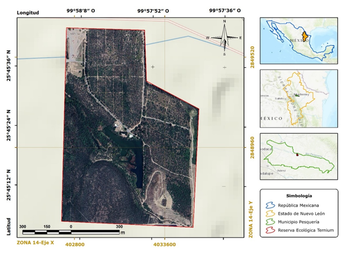
En el noreste de México, se estableció un área de conservación de la biodiversidad dentro de un complejo industrial, donde a partir del año 2010 se implementó un programa de reforestación con especies nativas. El objetivo fue evaluar cuantitativamente, mediante análisis multitemporal de imágenes de alta resolución, la efectividad de un proyecto de restauración ecológica en el Matorral Espinoso Tamaulipeco, en función de los cambios espaciales en la cobertura vegetal y el uso de suelo registrados entre 1995 y 2024. Los resultados indicaron un aumento lineal (R2=0.92) de la cobertura de la vegetación conforme transcurrió el tiempo. En 1995 ocupaba 32.22 % del área de conservación y en 2024, 62.67 %. En contraste, la superficie con agricultura disminuyó de 38.5 % en 1995 a 12.6 % en 2008, y fue nula a partir de 2014. Asimismo, la cobertura de pastizal se redujo de 27.1 % en 1995 a 17.1 % en 2024. Los resultados del estudio evidencian una recuperación de la cobertura vegetal como consecuencia de la implementación del programa de restauración ecológica en una superficie de 83 ha. Este incluyó la plantación de 69 537 individuos provenientes de rescates, 18 500 individuos de viveros locales; con una supervivencia de 85 % al año 2024, para al menos 10 especies de interés ecológico. Los hallazgos confirman la efectividad de dichas estrategias en el restablecimiento de la vegetación, que puede servir como base para el diseño e implementación de proyectos de restauración a mayor escala.
Descargas
Citas
Alanís-Rodríguez, E., Martínez-Adriano, C. A., Sánchez-Castillo, L., Rubio-Camacho, E. A., & Valdecantos, A. (2023). Land abandonment as driver of woody vegetation dynamics in Tamaulipan thornscrub at Northeastern Mexico. PeerJ, 11, Article e15438. https://doi.org/10.7717/peerj.15438 DOI: https://doi.org/10.7717/peerj.15438
Alanís-Rodríguez, E., Molina-Guerra, V. M., Collantes-Chavéz-Costa, A., Buendía-Rodríguez, E., Mora-Olivo, A., Sánchez-Castillo, L., & Alcalá-Rojas, A. G. (2021). Structure, composition and carbon stocks of woody plant community in assisted and unassisted ecological succession in a Tamaulipan thornscrub, Mexico. Revista Chilena de Historia Natural, 94, Article 6. https://doi.org/10.1186/s40693-021-00102-6 DOI: https://doi.org/10.1186/s40693-021-00102-6
Alanís-Rodríguez, E., Molina-Guerra, V. M., Rechy-Palmeros, L., Alcalá-Rojas, A. G., Marín-Solís, J. D., & Pequeño-Ledezma, M. Á. (2016). Composición, diversidad y supervivencia de un área restaurada en el Complejo Siderúrgico de Ternium, Pesquería, Nuevo León. En E. Ceccon & C. Martínez-Garza (Coords.), Experiencias mexicanas en la restauración de los ecosistemas (pp. 255-272). Universidad Nacional Autónoma de México. https://doi.org/10.22201/crim.9786070294778e.2017 DOI: https://doi.org/10.22201/crim.9786070294778e.2017
Alcalá-Rojas, A., Alanís-Rodríguez, E., Aguirre-Calderón, O., Cuellar-Rodríguez, G., Yerena-Yamellel, I., Martínez-Adriano, C. A., & Sandoval-García, R. (2025). Análisis de la regeneración natural en un área restaurada de 11 años en el matorral espinoso tamaulipeco. Revista Forestal Mesoamericana Kurú, 22(50), 80-88. https://doi.org/10.18845/rfmk.v22i50.7756 DOI: https://doi.org/10.18845/rfmk.v22i50.7756
Arneth, A., Leadley, P., Claudet, J., Coll, M., Rondinini, C., Rounsevell, M. D. A., Shin, Y.-J., Alexander, P., & Fuchs, R. (2023). Making protected areas effective for biodiversity, climate and food. Global Change Biology, 29(14), 3883-3894. https://doi.org/10.1111/gcb.16664 DOI: https://doi.org/10.1111/gcb.16664
Arriaga, L., Castellanos, A. E., Moreno, E., & Alarcón, J. (2004). Potential ecological distribution of alien invasive species and risk assessment: A case study of buffel grass in arid regions of Mexico. Conservation Biology, 18(6), 1504-1514. https://doi.org/10.1111/j.1523-1739.2004.00166.x DOI: https://doi.org/10.1111/j.1523-1739.2004.00166.x
Cámara de Diputados. (1988). Ley General del Equilibrio Ecológico y la Protección del Ambiente. Diario Oficial de la Federación. https://www.diputados.gob.mx/LeyesBiblio/pdf/LGEEPA.pdf
Doi, R. (2021). Assessing the reforestation effects of plantation plots in the Thai savanna based on 45 cm resolution true-color images and machine learning. Environmental Research Letters, 16, Article 014030. https://doi.org/10.1088/1748-9326/abcfe3 DOI: https://doi.org/10.1088/1748-9326/abcfe3
Food and Agriculture Organization of the United Nations. (1993). Forest Resources Assessment 1990. Survey of tropical forest cover and study of change processes-Tropical countries. Food and Agriculture Organization of the United Nations. https://www.fao.org/4/t0830e/t0830e00.htm
García, E., & Comisión Nacional para el Conocimiento y Uso de la Biodiversidad. (1998). Climas [Catálogo de metadatos geográficos]. Comisión Nacional para el Conocimiento y Uso de la Biodiversidad. http://geoportal.conabio.gob.mx/metadatos/doc/html/clima1mgw.html
Gutiérrez-Barrientos, M., Marín-Solís, J. D., Alanís-Rodríguez, E., & Buendía-Rodríguez, E. (2022). Evaluación de una restauración mediante dron en el matorral espinoso tamaulipeco. Polibotánica, (54), 71-85. https://doi.org/10.18387/polibotanica.54.5 DOI: https://doi.org/10.18387/polibotanica.54.5
Hernández-Cavazos, M. C., Sandoval-García, R., Molina-Guerra, V. M., & Alanís-Rodríguez, E. (2023). Análisis multitemporal del cambio de uso de suelo en el municipio de Linares, Nuevo León. Ecosistemas y Recursos Agropecuarios, 10(2), Artículo e3743. https://doi.org/10.19136/era.a10n2.3743 DOI: https://doi.org/10.19136/era.a10n2.3743
Instituto Nacional de Estadística y Geografía. (2024). Geografía y Medio Ambiente. Ortoimágenes [Banco de ortoimágenes]. Instituto Nacional de Estadística y Geografía. https://www.inegi.org.mx/temas/imagenes/ortoimagenes/#Descargas
Instituto Nacional de Estadística, Geografía e Informática. (2014). Conjunto de datos vectoriales de información topográfica G14C17 Doctor González escala 1:50 000, serie III [Conjunto de datos vectoriales]. Instituto Nacional de Estadística, Geografía e Informática. https://www.inegi.org.mx/app/biblioteca/ficha.html?upc=702825279127
Jumb, V., Sohani, M., & Shrivas, A. (2014). Color image segmentation using K-means clustering and Otsu’s adaptive thresholding. International Journal of Innovative Technology and Exploring Engineering, 3(9), 72-76. http://www.ijitee.org/wp-content/uploads/papers/v3i9/I1495023914.pdf
Landis, J. R., & Koch, G. G. (1977). The measurement of observer agreement for categorical data. Biometrics, 33(1), 159-174. https://pubmed.ncbi.nlm.nih.gov/843571/ DOI: https://doi.org/10.2307/2529310
León, O. A., & Vargas-Ríos, O. (2021). El monitoreo en la restauración ecológica: ¿por qué, para qué y cómo? En M. Aguilar-Garavito & W. Ramírez Hernández (Eds.), Evaluación y seguimiento de la restauración ecológica en el páramo andino (pp. 42-54). Instituto de Investigación de Recursos Biológicos Alexander von Humboldt. https://www.researchgate.net/publication/358088024_El_monitoreo_en_la_restauracion_ecologica_porque_para_que_y_como
Liu, C.-C., Chen, Y.-H., Wu, M.-H. M., Wei, C., & Ko, M.-H. (2019). Assessment of forest restoration with multitemporal remote sensing imagery. Scientific Reports, 9, Article 7279. https://doi.org/10.1038/s41598-019-43544-5 DOI: https://doi.org/10.1038/s41598-019-43544-5
Mao, L., Li, M., & Shen, W. (2020). Remote sensing applications for monitoring terrestrial protected areas: Progress in the last decade. Sustainability, 12(12), Article 5016. https://doi.org/10.3390/su12125016 DOI: https://doi.org/10.3390/su12125016
Marshall, V. M., Lewis, M. M., & Ostendorf, B. (2012). Buffel grass (Cenchrus ciliaris) as an invader and threat to biodiversity in arid environments: A review. Journal of Arid Environments, 78, 1-12. https://doi.org/10.1016/j.jaridenv.2011.11.005 DOI: https://doi.org/10.1016/j.jaridenv.2011.11.005
Molina-Guerra, V. M., Alanís-Rodríguez, E., Collantes-Chávez-Costa, A., Mora-Olivo, A., Buendía-Rodríguez, E., & de la Rosa-Manzano, E. (2023). Restauración de un fragmento de matorral espinoso tamaulipeco: respuesta de ocho especies leñosas. Colombia Forestal, 26(1), 36-47. https://doi.org/10.14483/2256201x.19056 DOI: https://doi.org/10.14483/2256201X.19056
Palacio-Prieto, J. L., Sánchez-Salazar, M. T., Casado-Izquierdo, J. M., Propin-Frejomil, E., Delgado-Campos, J., Velázquez-Montes, A., Chias-Becerril, L., Ortiz-Álvarez, M. I., González-Sánchez, J., Negrete-Fernández, G., Gabriel-Morales, J., & Márquez-Huitzil, R. (2004). Indicadores para la caracterización y Ordenamiento del Territorio. Universidad Nacional Autónoma de México, Secretaría de Desarrollo Social, Secretaría de Medio Ambiente y Recursos Naturales e Instituto Nacional de Ecología. https://unidadesdepaisaje.unam.mx/sites/default/files/2022-06/Palacio%20et%20al%2C%202004_0.pdf
Patiño-Flores, A. M., Alanís-Rodríguez, E., Molina-Guerra, V. M., González-Rodríguez, H., Jurado, E., & Aguirre-Calderón, O. A. (2019). Almacenamiento de carbono en la reserva ecológica de Ternium en Pesquería, Nuevo León. Revista Mexicana de Ciencias Forestales, 10(54), 39-57. https://doi.org/10.29298/rmcf.v10i54.498 DOI: https://doi.org/10.29298/rmcf.v10i54.498
Pequeño-Ledezma, M., Alanís-Rodríguez, E., Jiménez-Pérez, J., Aguirre-Calderón, O., González-Tagle, M., & Molina-Guerra, V. (2016). Criterios a considerar para desarrollar proyectos de restauración ecológica. Revista Iberoamericana de Ciencias, 3(2), 94-105. http://reibci.org/publicados/2016/jun/1600108.pdf
Pix4D. (2023). Pix4Dmapper (Versión 4.8.4) [Photogrammetry computer software]. Pix4D SA. https://www.pix4d.com/es/producto/pix4dmapper-fotogrametria-software/
Puyravaud, J.-P. (2003). Standardizing the calculation of the annual rate of deforestation. Forest Ecology and Management, 177(1-3), 593-596. https://doi.org/10.1016/S0378-1127(02)00335-3 DOI: https://doi.org/10.1016/S0378-1127(02)00335-3
QGIS Development Team. (2024). QGIS Geographic Information System (version 3.36.0 “Maidenhead”) [Software]. Open Source Geospatial Foundation Project. https://qgis.org
Quezada, A. S., Sevilla-Tapia, J. D., & Avilés-Sacoto, E. C. (2022). Estimación de la tasa de deforestación en Pastaza y Orellana-Ecuador mediante el análisis multitemporal de imágenes satelitales durante el período 2000-2020. Revista de Investigación en Ciencias Agronómicas y Veterinarias, 6(17), 282-299. https://doi.org/10.33996/revistaalfa.v6i17.168 DOI: https://doi.org/10.33996/revistaalfa.v6i17.168
Rashmi, C., Chaluvaiah, S., & Kumar, G. H. (2016). An efficient parallel block processing approach for K-means algorithm for high resolution orthoimagery satellite images. Procedia Computer Science, 89, 623-631. https://doi.org/10.1016/j.procs.2016.06.025 DOI: https://doi.org/10.1016/j.procs.2016.06.025
Reyna-Rojas, M. A., Saldaña-Fernández, M. C., García-Flores, A., Monroy-Ortiz, C., Valenzuela-Aguilera, A., & Valenzuela-Galván, D. (2021). El panorama actual de las Áreas Naturales Protegidas (ANP) de México. Ecosistemas, 30(1), Artículo 2068. https://doi.org/10.7818/ECOS.2068 DOI: https://doi.org/10.7818/ECOS.2068
Sandoval-García, R., González-Cubas, R., & Jiménez-Pérez, J. (2021). Multitemporal analysis of the change in land cover in the Mixteca Alta Oaxaqueña. Revista Mexicana de Ciencias Forestales, 12(66), 96-121. https://doi.org/10.29298/rmcf.v12i66.816 DOI: https://doi.org/10.29298/rmcf.v12i66.816
SASPlanet Development Team. (2024). SASPlanet (Stable) (version 200606.10075) [Software]. https://sasplanet.geojamal.com/
Descargas
Publicado
Cómo citar
Número
Sección
Licencia
Derechos de autor 2026 Revista Mexicana de Ciencias Forestales

Esta obra está bajo una licencia internacional Creative Commons Atribución-NoComercial 4.0.
Los autores que publiquen en la Revista Mexicana de Ciencias Forestales aceptan las siguientes condiciones:
De acuerdo con la legislación de derechos de autor, la Revista Mexicana de Ciencias Forestales reconoce y respeta el derecho moral de los autores, así como la titularidad del derecho patrimonial, el cual será cedido a la revista para su difusión en acceso abierto.
Todos los textos publicados por la Revista Mexicana de Ciencias Forestales –sin excepción– se distribuyen amparados bajo la licenciaCreative Commons 4.0 Atribución-No Comercial (CC BY-NC 4.0 Internacional), que permite a terceros utilizar lo publicado siempre que mencionen la autoría del trabajo y a la primera publicación en esta revista. (no permite el uso comercial)
Los autores pueden realizar otros acuerdos contractuales independientes y adicionales para la distribución no exclusiva de la versión del artículo publicado en la Revista Mexicana de Ciencias Forestales (por ejemplo, incluirlo en un repositorio institucional o darlo a conocer en otros medios en papel o electrónicos) siempre que indique clara y explícitamente que el trabajo se publicó por primera vez en la Revista Mexicana de Ciencias Forestales.
Para todo lo anterior, los autores deben remitir el formato de carta-cesión de la propiedad de los derechos de la primera publicación debidamente requisitado y firmado por los autores/as. Este formato debe ser remitido en archivo PDF al correo: editorial.forestal@inifap.gob.mx
Esta obra está bajo una licencia de Creative Commons Reconocimiento-No Comercial 4.0 Internacional.