Comparison of models to estimate DBH of Pinus hartwegii Lindl. with LiDAR data
DOI:
https://doi.org/10.29298/rmcf.v16i92.1579Keywords:
airbone, Individual Trees, LiDAR, Pinus hartwegii Lindl., regression, remote sensingAbstract
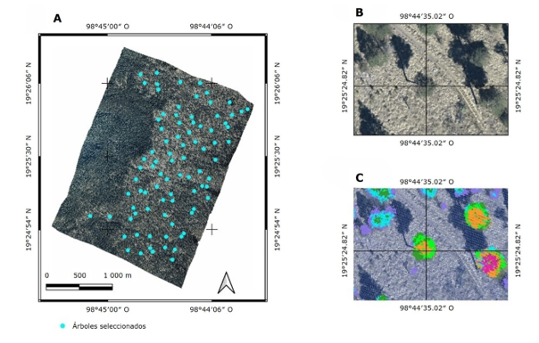
DBH is a fundamental variable in forest management. Airborne LiDAR sensors have demonstrated their usefulness in supporting forest inventories; however, it is not possible to directly measure DBH with them. Pinus hartwegii is the main tree species in the highlands of Mexico, providing important ecosystem services such as carbon sequestration and rainwater infiltration. The objective of this study was to design an equation to estimate the DBH of individual P. hartwegii trees, based on tree measurements obtained from airborne LiDAR data. 85 identifiable P. hartwegii trees were selected on a digital orthomosaic and their UTM coordinates were recorded. With these coordinates they were located in the field and their DBH, total height, height to crown base and crown diameter were measured. They were located in a LiDAR point cloud and the same variables were measured as in the field, except for the DBH. 29 models reported in the literature were evaluated to estimate normal diameter, using 7 independent variables obtained from the LiDAR data. The best model (M27) is an adaptation of the one known in the literature as Gompertz. It obtained an R2adj=0.884, RMSE=6.5 cm. The validation results indicate that its estimates are adequate for calculating the DBH from the total height and crown diameter obtained from LiDAR data.
Downloads
References
Allouis, T., Durrieu, S., Véga, C., & Couteron, P. (2013). Stem volume and above-ground biomass estimation of individual pine trees from LiDAR data: Contribution of full-waveform signals. IEEE Journal of Selected Topics in Applied Earth Observations and Remote Sensing, 6(2), 924-934. https://www.researchgate.net/publication/236847673_Stem_Volume_and_Above-Ground_Biomass_Estimation_of_Individual_Pine_Trees_From_LiDAR_Data_Contribution_of_Full-Waveform_Signals DOI: https://doi.org/10.1109/JSTARS.2012.2211863
Ancira-Sánchez, L., y Treviño-Garza, E. J. (2015). Utilización de imágenes de satélite en el manejo forestal del noreste de México. Madera y Bosques, 21(1), 77-91. http://doi.org/10.21829/myb.2015.211434 DOI: https://doi.org/10.21829/myb.2015.211434
Bi, H., Fox, J. C., Li, Y., Lei, Y., & Pang, Y. (2012). Evaluation of nonlinear equations for predicting diameter from tree height. Canadian Journal of Forest Research, 42(4), 789-806. http://doi.org/10.1139/X2012-019 DOI: https://doi.org/10.1139/x2012-019
Comisión Nacional de Áreas Naturales Protegidas. (2013). Programa de Manejo Parque Nacional Iztaccíhuatl Popocatépetl [Libro blanco]. Secretaría de Medio Ambiente y Recursos Naturales. https://www.conanp.gob.mx/que_hacemos/pdf/programas_manejo/2014/IZTA_POPO_2014.pdf
Coombes, A., Martin, J., & Slater, D. (2019). Defining the allometry of stem and crown diameter of urban trees. Urban Forestry & Urban Greening, 44, Article 126421. https://doi.org/10.1016/j.ufug.2019.126421 DOI: https://doi.org/10.1016/j.ufug.2019.126421
Fau, C., Nabzo, S., y Nasabun, V. (2020). Bondad de ajuste y análisis de concordancia. Revista Mexicana de Oftalmología, 94(2), 100-102. https://www.scielo.org.mx/scielo.php?script=sci_arttext&pid=S2604-12272020000200100 DOI: https://doi.org/10.24875/RMO.M20000107
Fox, J. (2015). Applied regression analysis and generalized linear models (3rd ed.). Sage Publications, Inc. https://uk.sagepub.com/en-gb/eur/applied-regression-analysis-and-generalized-linear-models/book237254
Fu, L., Liu, Q., Sun, H., Wang, Q., Li, Z., Chen, E., Pang, Y., Song, X., & Wang, G. (2018). Development of a system of compatible individual tree diameter and aboveground biomass prediction models using error-in-variable regression and airborne LiDAR data. Remote Sensing, 10(2), Article 325. https://doi.org/10.3390/rs10020325 DOI: https://doi.org/10.3390/rs10020325
Galvincio, J. D., & Popescu, S. C. (2016). Measuring individual tree height and crown diameter for mangrove trees with airborne Lidar data. International Journal of Advanced Engineering, Management and Science, 2(5), 431-443. https://ijaems.com/detail/measuring-individual-tree-height-and-crown-diameter-for-mangrove-trees-with-airborne-lidar-data/
Guo, Q., Su, Y., Hu, T., Guan, H., Jin, S., Zhang, J., Zhao, X., Xu, K., Wei, D., Kelli, M., & Coops, N. C. (2021). Lidar boosts 3D ecological observations and modelings: A review and perspective. IEEE Geoscience and Remote Sensing Magazine, 9(1), 232-257. https://doi.org/10.1109/MGRS.2020.3032713 DOI: https://doi.org/10.1109/MGRS.2020.3032713
Hall, R. J., Morton, R. T., & Nesby, R. N. (1989). A comparison of existing models for DBH estimation from large-scale photos. The Forestry Chronicle, 65(2), 114-120. http://doi.org/10.5558/tfc65114-2 DOI: https://doi.org/10.5558/tfc65114-2
Hernández, F. J., Meraz-Aragón, J. C., Vargas-Larreta, B., & Nájera-Luna, J. A. (2020). Diameter, height, basal area and volume growth of three pine species from Chihuahua, Mexico. Revista Mexicana de Ciencias Forestales, 11(60), 120-143. https://doi.org/10.29298/rmcf.v11i60.711 DOI: https://doi.org/10.29298/rmcf.v11i60.711
Hernández-Cuevas, M., Santiago-García, W., De los Santos-Posadas, H. M., Martínez-Antúnez, P., & Ruiz-Aquino, F. (2018). Modelos de crecimiento en altura dominante e índices de sitio para Pinus ayacahuite Ehren. Agrociencia, 52(3), 437-453. https://agrociencia-colpos.org/index.php/agrociencia/article/view/1680
Hernández-Ramírez, V., López-Mata, L., Cruz-Rodríguez, J. A., y Luna-Cavazos, M. (2022). Nicho de regeneración de Abies religiosa (Kunth) Schltdl. & Cham. en el Monte Tláloc, Parque Nacional Iztaccíhuatl-Popocatépetl, México. Botanical Sciences, 100(2), 331-344. http://doi.org/10.17129/botsci.2912 DOI: https://doi.org/10.17129/botsci.2912
Hulshof, C. M., Swenson, N. G., & Weiser, M. D. (2015). Tree height–diameter allometry across the United States. Ecology and Evolution, 5(6), 1193-1204. http://doi.org/10.1002/ece3.1328 DOI: https://doi.org/10.1002/ece3.1328
Islas-Gutiérrez, F., Guerra-De la Cruz, V., Buendía-Rodríguez, E., Pineda-Ojeda, T., Flores-Ayala, E., y Cruz-Juárez, E. (2023). Ecuación para estimar el diámetro normal de árboles individuales de Pinus hartwegii Lindl. con datos LiDAR. Revista Tecnológica CEA, 8(23), 515-521. https://revistatecnologicacea.mx/revista22/
Koo, T. K., & Li, M. Y. (2016). A guideline of selecting and reporting intraclass correlation coefficients for reliability research. Journal of Chiropractic Medicine, 15(2), 155-163. http://dx.doi.org/10.1016/j.jcm.2016.02.012 DOI: https://doi.org/10.1016/j.jcm.2016.02.012
Lara-Vásconez, N., y Chamorro-Sevilla, H. (2018). Uso de los sensores remotos en mediciones forestales. European Scientific Journal, 14(15), 58-77. http://doi.org/10.19044/esj.2018.v14n15p58 DOI: https://doi.org/10.19044/esj.2018.v14n15p58
Liu, W., Zhong, T., & Song, Y. (2017). Prediction of trees diameter at breast height based on unmanned aerial vehicle image analysis. Transactions of the Chinese Society of Agricultural Engineering, 33(21), 99-104. http://doi.org/10.11975/j.issn.1002-6819.2017.21.012
Ma, L., Liu, Y., Zhang, X., Ye, Y., Yin, G., & Johnson, B. A. (2019). Deep learning in remote sensing applications: A meta-analysis and review. ISPRS Journal of Photogrammetry and Remote Sensing, 152, 166-177. https://doi.org/10.1016/j.isprsjprs.2019.04.015 DOI: https://doi.org/10.1016/j.isprsjprs.2019.04.015
Martínez-Pérez, J. A., y Pérez-Martín, P. S. (2023). Coeficiente de correlación intraclase. Medicina de Familia SEMERGEN, 49(3), Article 101907. https://doi.org/10.1016/j.semerg.2022.101907 DOI: https://doi.org/10.1016/j.semerg.2022.101907
McGaughey, R. J. (2024). FUSION/LDV: Software for LIDAR Data Analysis and Visualization. FUSION Version 4.61. United States Department of Agriculture. https://forsys.sefs.uw.edu/software/fusion/FUSION_manual.pdf
Mehtätalo, L., de-Miguel, S., & Gregoire, T. M. (2015). Modeling height-diameter curves for prediction. Canadian Journal of Forest Research, 45(7), 826-837. http://doi.org/10.1139/cjfr-2015-0054 DOI: https://doi.org/10.1139/cjfr-2015-0054
Montes de Oca-Cano, E., Salvador-García, Á., Nájera-Luna, J. A., Corral-Rivas, S., Graciano-Luna, J. de J., y Méndez-González, J. (2020). Ecuaciones alométricas para estimar biomasa y carbono en Trichospermum mexicanum (DC.) Baill. Colombia Forestal, 23(2), 89-98. https://doi.org/10.14483/2256201x.15836 DOI: https://doi.org/10.14483/2256201X.15836
Ng'andwe, P., Chungu, D., Yambayamba, A. M., & Chilambwe, A. (2019). Modeling the height-diameter relationship of planted Pinus kesiya in Zambia. Forest Ecology and Management, 447, 1-11. http://doi.org/10.1016/j.foreco.2019.05.051 DOI: https://doi.org/10.1016/j.foreco.2019.05.051
Ogana, F. N. (2019). Modelling crown-stem diameters relationship for the management of Tectona grandis Linn f. plantation in Omo Forest Reserve, Western Nigeria. Annals of Silvicultural Research, 43(2), 89-96. https://doi.org/10.12899/asr-1865
Oono, K., & Tsuyuki, S. (2018). Estimating individual tree diameter and stem volume using airborne LiDAR in Saga Prefecture, Japan. Open Journal of Forestry, 8(2), 205-228. http://doi.org/10.4236/ojf.2018.82015 DOI: https://doi.org/10.4236/ojf.2018.82015
Ott, R. L., & Longnecker, M. (2010). An introduction to statistical methods and data analysis (6th ed.). Cengage Learning Inc. http://repository.bitscollege.edu.et:8080/bitstream/handle/123456789/789/LYMANO~1.PDF?sequence=1
Pérez-Suárez, M., Ramírez-Albores, J. E., Vargas-Hernández, J. J., & Alfaro-Ramírez, F. U. (2022). A review of the knowledge of Hartweg´s pine (Pinus hartwegii Lindl.): current situation and the need for improved future projections. Trees, 36, 25-37. http://doi.org/10.1007/s00468-021-02221-9 DOI: https://doi.org/10.1007/s00468-021-02221-9
QGIS Development Team. (2024). QGIS Geographic Information System (version 3.42) [Software]. Open Source Geospatial Foundation Project. http://qgis.osgeo.org
R Core Team. (2025). The R Project for Statistical Computing (version 4.4.3) [Software]. R Foundation for Statistical Computing. https://www.R-project.org/
Reutebuch, S. E., Andersen, H.-E., & McGaughey, R. J. (2005). Light detection and ranging (LIDAR): An emerging tool for multiple resource inventory. Journal of Forestry, 103(6), 286-292. https://www.fs.usda.gov/pnw/pubs/journals/pnw_2005_reutebuch001.pdf DOI: https://doi.org/10.1093/jof/103.6.286
SAS Institute Inc. (2011). SAS Version 9.3 [Software]. SAS Institute Inc. https://www.sas.com/en_us/home.html
Shiota, H., Tanaka, K., & Nagashima, K. (2017). LiDAR data analysis with Fusion/LDV for individual tree measurement. Journal of Biodiversity Management and Forestry, 6(3), 1-8. http://doi.org/10.4172/2327-4417.1000184 DOI: https://doi.org/10.4172/2327-4417.1000184
Tamarit-Urías, J. C., De los Santos-Posadas, H. M., Aldrete, A., Valdez-Lazalde, J. R., Ramírez-Maldonado, H., y Guerra-De la Cruz, V. (2014). Sistema de cubicación para árboles individuales de Tectona grandis L. f. mediante funciones compatibles de ahusamiento-volumen. Revista Mexicana de Ciencias Forestales, 5(21), 58-74. http://doi.org/10.29298/rmcf.v5i21.358 DOI: https://doi.org/10.29298/rmcf.v5i21.358
Valverde, J. C., Rubilar, R., Medina, A., Mardones, O., Emhart, V., Bozo, D., Espinoza, Y., & Campoe, O. (2022). Taper and individual tree volume equations of Eucalyptus varieties under contrasting irrigation regimes. New Zealand Journal of Forestry Science, 52, Article 15. http://doi.org/10.33494/nzjfs522022x181x DOI: https://doi.org/10.33494/nzjfs522022x181x
Verma, N. K., Lamb, D. W., Reid, N., & Wilson, B. (2014). An allometric model for estimating DBH of isolated and clustered Eucalyptus trees from measurements of crown projection area. Forest Ecology and Management, 326, 125-132. http://doi.org/10.1016/j.foreco.2014.04.003 DOI: https://doi.org/10.1016/j.foreco.2014.04.003
Wang, R., & Gamon, J. A. (2019). Remote sensing of terrestrial plant biodiversity. Remote Sensing of Environment, 231, Article 111218. https://doi.org/10.1016/j.rse.2019.111218 DOI: https://doi.org/10.1016/j.rse.2019.111218
Yang, Z., Liu, Q., Luo, P., Ye, Q., Duan, G., Sharma, R. P., Zhang, H., Wang, G., & Fu, L. (2020). Prediction of individual tree diameter and height to crown base using nonlinear simultaneous regression and airborne LiDAR data. Remote Sensing, 12(14), Article 2238. https://doi:10.3390/rs12142238 DOI: https://doi.org/10.3390/rs12142238
Zhang, Z., Wang, T., Skidmore, A. K., Cao, F., She, G., & Cao, L. (2023). An improved area-based approach for estimating plot-level tree DBH from airborne LiDAR data. Forest Ecosystems, 10, Article 100089. http://doi.org/10.1016/j.fecs.2023.100089 DOI: https://doi.org/10.1016/j.fecs.2023.100089
Published
How to Cite
Issue
Section
License
Copyright (c) 2025 Revista Mexicana de Ciencias Forestales

This work is licensed under a Creative Commons Attribution-NonCommercial 4.0 International License.
The authors who publish in Revista Mexicana de Ciencias Forestales accept the following conditions:
In accordance with copyright laws, Revista Mexicana de Ciencias Forestales recognizes and respects the authors’ moral right and ownership of property rights which will be transferred to the journal for dissemination in open access.
All the texts published by Revista Mexicana de Ciencias Forestales –with no exception– are distributed under a Creative Commons License Attribution-NonCommercial 4.0 International (CC BY-NC 4.0), which allows third parties to use the publication as long as the work’s authorship and its first publication in this journal are mentioned
The author(s) can enter into independent and additional contractual agreements for the nonexclusive distribution of the version of the article published in Revista Mexicana de Ciencias Forestales (for example, include it into an institutional repository or publish it in a book) as long as it is clearly and explicitly indicated that the work was published for the first time in Revista Mexicana de Ciencias Forestales.
For all the above, the authors shall send the form of Letter-transfer of Property Rights for the first publication duly filled in and signed by the author(s). This form must be sent as a PDF file to: ciencia.forestal2@inifap.gob.mx
This work is licensed under a Creative Commons Attribution-Noncommercial 4.0 International license.