Spatial variability of mistletoe (Loranthaceae) in green areas of Coyoacán municipality, Mexico City
DOI:
https://doi.org/10.29298/rmcf.v15i85.1469Keywords:
Aggregation, Urban forests, Geostatistics, Ordinary Kriging, True mistletoe, SADIEAbstract
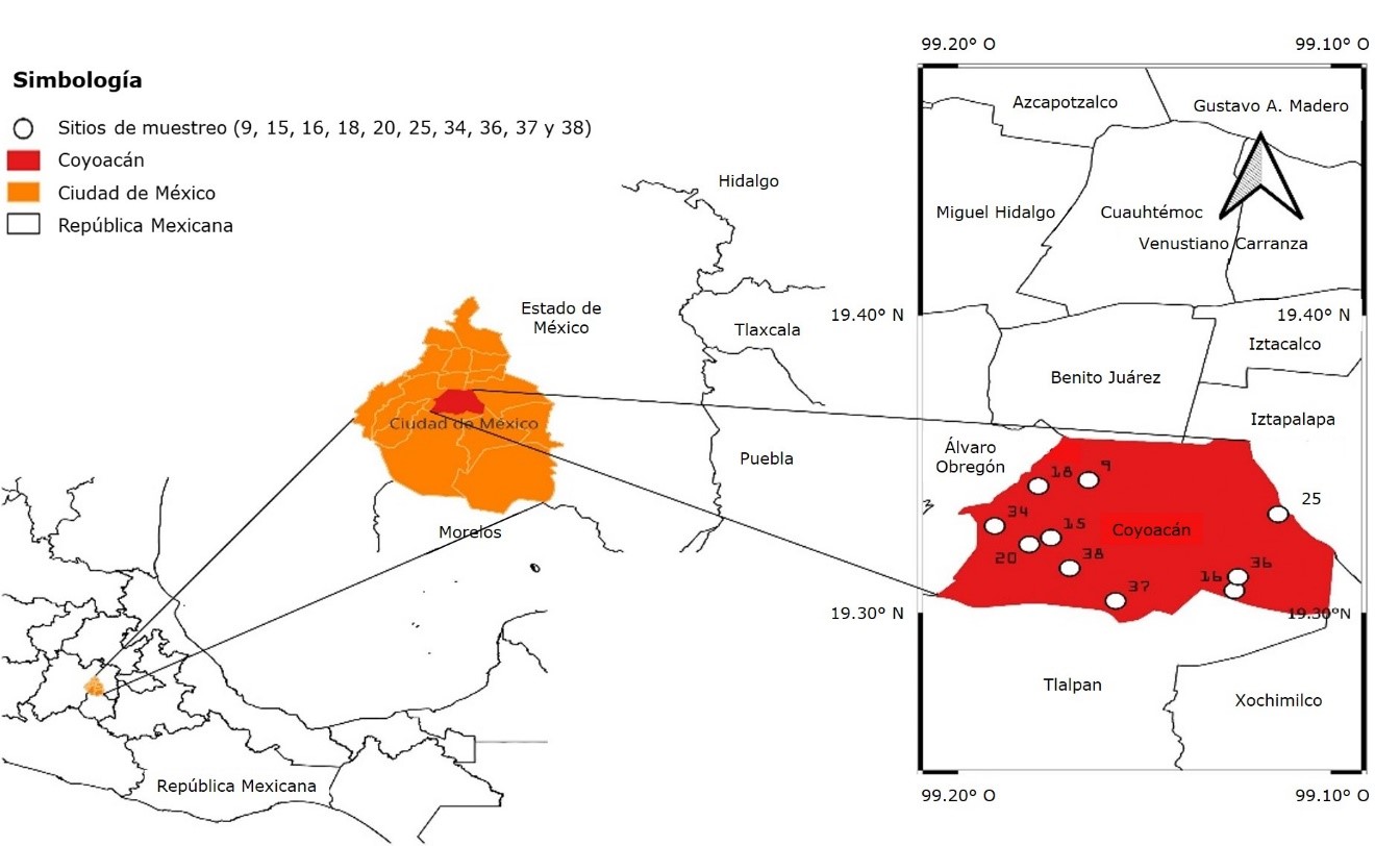
Urban forests are green spaces designed to improve the relationship between nature and people, but due to their strong interaction with people they must be protected. Urban trees grow under greater environmental stress which makes them more susceptible to pests and diseases, including parasitic plants such as true mistletoe. The Cladocolea genus, known as true mistletoe, corresponds to parasitic plants of great interest to arborists, since they infest trees and shrubs, and cause severe damage to hosts. The present research aimed to establish the type of spatial variability of true mistletoe populations in urban green areas of the Coyoacán municipality of Mexico City through the use of Geostatistics. 38 sites of said demarcation were sampled, of which the parasitic plant was identified in 10. Experimental and theoretical semivariograms, pest aggregation maps and an estimation of the infested area were developed using Geostatistics, and the Ia and Ja indices were determined using SADIE. The results showed that mistletoe has an aggregated distribution that fits the exponential, Gaussian and spherical statistical models, with an aggregated spatial distribution, which helps in the development of phytosanitary management programs for urban trees.
Downloads
References
Aukema, J. E. 2004. Distribution and dispersal of desert mistletoe is scale-dependent, hierarchically nested. Ecography 27(2):137-144. Doi: 10.1111/j.0906-7590.2004.03640.x. DOI: https://doi.org/10.1111/j.0906-7590.2004.03640.x
Byamukama, E., A. E. Robertson and F. W. Nutter Jr. 2011. Quantifying the within-field temporal and spatial dynamics of bean pod mottle virus in Soybean. Plant Disease 95(2):126-136. Doi: 10.1094/PDIS-07-09-0469. DOI: https://doi.org/10.1094/PDIS-07-09-0469
Cambardella, C. A., T. B. Moorman, J. M. Novak, T. B. Parkin, … and A. E. Konopka. 1994. Field-scale variability of soil properties in central Iowa soils. Soil Science Society of America Journal 58(5):1501-1511. Doi: 10.2136/sssaj1994.03615995005800050033x. DOI: https://doi.org/10.2136/sssaj1994.03615995005800050033x
Cantón, M. A., C. de Rosa y H. Kasperidus. 2003. Sustentabilidad del bosque urbano en el área metropolitana de la ciudad de Mendoza. Análisis y diagnóstico de la condición de las arboledas. Avances en Energías Renovables y Medio Ambiente 7(1):29-34. http://sedici.unlp.edu.ar/handle/10915/80662. (6 de enero de 2023).
Cibrián T., D., D. Alvarado R. y S. E. García D. (Edits.). 2007. Enfermedades forestales en México. Universidad Autónoma Chapingo. Texcoco, Edo. Méx., México. 587 p.
Comisión Nacional Forestal y Colegio de Postgraduados (Conafor y Colpos). 2012. Guía pictórica de campo. Agentes de daño en los bosques de México. Gerencia de Sanidad, Conafor. Zapopan, Jal., México. 60 p.
Díaz-Limón, M. P., Z. Cano-Santana and M. E. Queijeiro-Bolaños. 2016. Mistletoe infection in an urban forest in Mexico City. Urban Forestry & Urban Greening 17:126-134. Doi: 10.1016/j.ufug.2016.04.004. DOI: https://doi.org/10.1016/j.ufug.2016.04.004
Espinoza-Zúñiga, P., J. F. Ramírez-Dávila, D. Cibrián-Tovar, A. Villanueva-Morales, … y R. Rivera-Martínez. 2019. Modelación de la distribución espacial del muérdago (Santalales: Loranthaceae) en las áreas verdes de la delegación Tlalpan, México. Bosque 40(1):17-28. Doi: 10.4067/S0717-92002019000100017. DOI: https://doi.org/10.4067/S0717-92002019000100017
Fernández D., M., J. G. Espinosa R. y C. R. García-Jacas. 2016. Algoritmo paralelo para la interpolación espacial de Krigeado Ordinario. Revista Cubana de Ciencias Informáticas 10(3):57-70. http://scielo.sld.cu/pdf/rcci/v10n3/rcci05316.pdf. (24 de enero de 2023).
Gougherty, A. V. 2013. Spatial distribution of Eastern mistletoe (Phoradendron leucarpum, Viscaceae) in an urban environment. Journal of the Alabama Academy of Science 84(3-4):155-167. https://openurl.ebsco.com/EPDB%3Agcd%3A6%3A511398/detailv2?sid=ebsco%3Aplink%3Ascholar&id=ebsco%3Agcd%3A96642631&crl=c. (23 de abril de 2023).
Gringarten, E. and C. V. Deutsch. 2001. Teacher's Aide variogram interpretation and modeling. Mathematical Geology 33:507-534. Doi: 10.1023/A:1011093014141. DOI: https://doi.org/10.1023/A:1011093014141
Hevesi, J. A., J. D. Istok and A. L. Flint. 1992. Precipitation estimation in mountainous terrain using multivariate Geostatistics. Part I: Structural analysis. Journal of Applied Meteorology 31(7):661-676. https://www.jstor.org/stable/26186579. (18 de febrero de 2023). DOI: https://doi.org/10.1175/1520-0450(1992)031<0661:PEIMTU>2.0.CO;2
Instituto Nacional de Estadística y Geografía (INEGI). 2010. Compendio de Información Geográfica Delegacional de los Estados Unidos Mexicanos. Coyoacán, Distrito Federal, clave geoestadística 09003. Aguascalientes, Ags., México. 6 p.
Isaaks, E. H. and R. M. Srivastava. 1988. Spatial continuity measures for probabilistic and deterministic geostatistics. Mathematical Geology 20:313-341. Doi: 10.1007/BF00892982. DOI: https://doi.org/10.1007/BF00892982
Journel, A. G. and C. J. Huijbregts. 1978. Mining Geostatistics. Academic Press Limited. Ipswich, SFK, England. 600 p.
Lara-Vázquez, F., J. F. Ramírez-Dávila, M. Rubí-Arriaga, E. J. Morales-Rosales, ... y R. Rivera-Martínez. 2018. Distribución espacial de araña roja Oligonychus punicae Hirst en el cultivo del aguacate, en dos municipios del Estado de México. Southwestern Entomologist 43(3):743-759. Doi: 10.3958/059.043.0320. DOI: https://doi.org/10.3958/059.043.0320
Maestre, F. T. 2003. Variaciones en el patrón espacial a pequeña escala de los componentes de la costra biológica en un ecosistema mediterráneo semiárido. Revista Chilena de Historia Natural 76(1):35-46. Doi: 10.4067/S0716-078X2003000100004. DOI: https://doi.org/10.4067/S0716-078X2003000100004
Maldonado Z., F. I., J. F. Ramírez D., M. Rubí A., X. Antonio N. y A. V. Lara D. 2016. Distribución espacial de trips en aguacate en Coatepec Harinas, Estado de México. Revista Mexicana de Ciencias Agrícolas 7(4):845-856. Doi: 10.29312/remexca.v7i4.259. DOI: https://doi.org/10.29312/remexca.v7i4.259
Martínez-Castruita, I. A., M. H. Sandoval-Ortega, M. Arellano-Delgado y V. M. Martínez-Calderón. 2021. Infestación por Cladocolea loniceroides y sus potenciales aves dispersoras de semillas en un área verde urbana de la ciudad de Aguascalientes, México. Madera y Bosques 27(1):e2712084. Doi: 10.21829/myb.2021.2712084. DOI: https://doi.org/10.21829/myb.2021.2712084
Martínez-Martínez, N., J. F. Ramírez-Dávila, F. Lara-Vázquez y D. K. Figueroa-Figueroa. 2021. Distribución espacial de muérdago enano en la Reserva de la Biosfera Mariposa Monarca. Colombia Forestal 24(2):65-81. Doi: 10.14483/2256201X.17163. DOI: https://doi.org/10.14483/2256201X.17163
Mathiasen, R. L., D. L. Nickrent, D. C. Shaw and D. M. Watson. 2008. Mistletoes: Pathology, systematics, ecology, and management. Plant disease 92(7):988-1006. Doi: 10.1094/PDIS-92-7-0988. DOI: https://doi.org/10.1094/PDIS-92-7-0988
Matula, R., M. Svátek, M. Pálková, D. Volřík and T. Vrška. 2015. Mistletoe infection in an oak forest is influenced by competition and host size. PLOS ONE 10(5):e0127055. Doi: 10.1371/journal.pone.0127055. DOI: https://doi.org/10.1371/journal.pone.0127055
Moral G., F. J. 2004. Aplicación de la geoestadística en las ciencias ambientales. Ecosistemas 13(1):78-86. https://www.revistaecosistemas.net/index.php/ecosistemas/article/view/582. (11 de noviembre de 2022).
Perry, J. N. 1995. Spatial analysis by distance index. Journal of Animal Ecology 64(3):303-314. Doi: 10.2307/5892. DOI: https://doi.org/10.2307/5892
Perry, J. N. 1998. Measures of spatial pattern for counts. Ecology 79(3):1008-1017. https://doi.org/10.1890/0012-9658(1998)079[1008:MOSPFC]2.0.CO;2. DOI: https://doi.org/10.1890/0012-9658(1998)079[1008:MOSPFC]2.0.CO;2
Ramírez D., J. F. y E. Porcayo C. 2010. Estudio comparativo de la distribución espacial del muérdago enano (Arceuthobium sp.) en la ladera norte del Parque Nacional Nevado de Toluca, México. Bosque 31(1):28-38. Doi: 10.4067/S0717-92002010000100004. DOI: https://doi.org/10.4067/S0717-92002010000100004
Ramírez-Dávila, J. F, J. R. Sánchez-Pale, E. Porcayo-Camargo and C. de León. 2012. Determination of spatiotemporal stability of corn head smut (Sporisorium reilianum) by SADIE. Ciencia e Investigación Agraria 39(3):459-471. Doi: 10.4067/S0718-16202012000300006. DOI: https://doi.org/10.4067/S0718-16202012000300006
Ramírez-Dávila, J. F. y E. Porcayo-Camargo. 2008. Distribución espacial de las ninfas de Jacobiasca lybica (Hemiptera: Cicadellidae) en un viñedo en Andalucía, España. Revista Colombiana de Entomología 34(2):169-175. Doi: 10.25100/socolen.v34i2.9282. DOI: https://doi.org/10.25100/socolen.v34i2.9282
Ricotta, C., L. C. Grapow, G. Avena and C. Blasi. 2001. Topological analysis of the spatial distribution of plant species richness across the city of Rome (Italy) with the echelon approach. Landscape and Urban Planning 57(2):69-76. Doi: 10.1016/S0169-2046(01)00187-6. DOI: https://doi.org/10.1016/S0169-2046(01)00187-6
Samper, F. J. y J. Carrera. 1996. Geoestadística: Aplicaciones a la hidrogeología subterránea. Centro Internacional de Métodos Numéricos en Ingeniería. Barcelona, CT, España. 484 p.
Sayad, E., E. Boshkar and S. Gholami. 2017. Different role of host and habitat features in determining spatial distribution of mistletoe infection. Forest Ecology and Management 384:323-330. Doi: 10.1016/j.foreco.2016.11.012. DOI: https://doi.org/10.1016/j.foreco.2016.11.012
Secretaría del Medio Ambiente (Sedema). 2010. Inventario de Áreas Verdes. https://sedema.cdmx.gob.mx/programas/programa/inventario-de-areas-verdes. (16 de diciembre de 2022).
Solís-Gracia, V. y H. Suzán-Aspiri. 2014. Análisis de la distribución espacial del muérdago (Phoradendron californicum) en el sur del Desierto Sonorense. Cactáceas y Suculentas Mexicanas 59(1):11-28. https://www.academia.edu/49357091/Cact%C3%A1ceas_y_Suculentas_Mexicanas_Volumen_59_No_1_enero_marzo_2014. (18 de enero de 2023).
Souza, E. G., C. L. Bazzi, R. Khosla, M. A. Uribe-Opazo and R. M. Reich. 2016. Interpolation type and data computation of crop yield maps is important for precision crop production. Journal of Plant Nutrition 39(4):531-538. Doi: 10.1080/01904167.2015.1124893. DOI: https://doi.org/10.1080/01904167.2015.1124893
Published
How to Cite
Issue
Section
License
Copyright (c) 2024 Revista Mexicana de Ciencias Forestales

This work is licensed under a Creative Commons Attribution-NonCommercial 4.0 International License.
The authors who publish in Revista Mexicana de Ciencias Forestales accept the following conditions:
In accordance with copyright laws, Revista Mexicana de Ciencias Forestales recognizes and respects the authors’ moral right and ownership of property rights which will be transferred to the journal for dissemination in open access.
All the texts published by Revista Mexicana de Ciencias Forestales –with no exception– are distributed under a Creative Commons License Attribution-NonCommercial 4.0 International (CC BY-NC 4.0), which allows third parties to use the publication as long as the work’s authorship and its first publication in this journal are mentioned
The author(s) can enter into independent and additional contractual agreements for the nonexclusive distribution of the version of the article published in Revista Mexicana de Ciencias Forestales (for example, include it into an institutional repository or publish it in a book) as long as it is clearly and explicitly indicated that the work was published for the first time in Revista Mexicana de Ciencias Forestales.
For all the above, the authors shall send the form of Letter-transfer of Property Rights for the first publication duly filled in and signed by the author(s). This form must be sent as a PDF file to: ciencia.forestal2@inifap.gob.mx
This work is licensed under a Creative Commons Attribution-Noncommercial 4.0 International license.