Diagnóstico y priorización del arbolado urbano en una ciudad semiárida con Sentinel-2 y Random Forest
DOI:
https://doi.org/10.29298/rmcf.v17i98.1678Palabras clave:
Cobertura vegetal urbana, déficit de verde urbano, Google Earth Engine, infraestructura verde, temperatura superficial terrestre, textura GLCMResumen
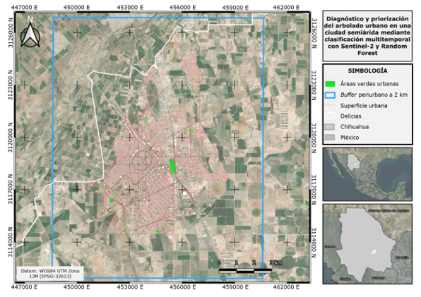
El déficit de arbolado urbano en ciudades semiáridas es un problema de adaptación climática que los inventarios municipales tradicionales subestiman. En este estudio se diagnostican y priorizan zonas de intervención arbórea en las áreas verdes registradas de la ciudad de Delicias, Chihuahua mediante clasificación supervisada multitemporal de Sentinel-2 con Random Forest (RF), validación cruzada del inventario municipal y un índice de prioridad basado en el déficit de cobertura y la temperatura superficial terrestre. Se construyeron composiciones estacionales de verano e invierno 2023-2024, y se extrajeron 17 variables espectrales, de textura GLCM y temporales. El RF completo alcanzó una exactitud global de 89.1 % (Kappa=0.662), con el NDVI de verano como variable más discriminante. Apenas 3.0 % de la superficie urbana correspondió a vegetación funcional (7.17 m2 hab-1), y solo 24.6 % de las 88.7 ha catalogadas como áreas verdes presentó cobertura detectable, lo cual evidenció una sobreestimación sistemática del padrón oficial. A partir del índice se identificaron 110 espacios de intervención urgente, con cobertura media de 4.4 % y estrés térmico severo. Los resultados sustentan la necesidad de reformar los criterios municipales de registro hacia estándares verificables mediante teledetección, y demuestran la viabilidad del enfoque satelital para auditar el verde urbano en ciudades medias semiáridas.
Descargas
Referencias
Belgiu, M., & Drăguţ, L. (2016). Random forest in remote sensing: A review of applications and future directions. ISPRS Journal of Photogrammetry and Remote Sensing, 114, 24-31. https://doi.org/10.1016/j.isprsjprs.2016.01.011
Borelli, S., Conigliaro, M., & Pineda, F. (2018). Los bosques urbanos en el contexto global. Unasylva: Revista Internacional de Silvicultura e Industrias Forestales, 69(250), 3-10. https://dialnet.unirioja.es/servlet/articulo?codigo=7455599
Bowler, D. E., Buyung-Ali, L., Knight, T. M., & Pullin, A. S. (2010). Urban greening to cool towns and cities: A systematic review of the empirical evidence. Landscape and Urban Planning, 97(3), 147-155. https://doi.org/10.1016/j.landurbplan.2010.05.006
Breiman, L. (2001). Random forests. Machine Learning, 45, 5-32. https://doi.org/10.1023/A:1010933404324
Cohen, J. (1960). A coefficient of agreement for nominal scales. Educational and Psychological Measurement, 20(1), 37-46. https://doi.org/10.1177/001316446002000104
Congalton, R. G. (1991). A review of assessing the accuracy of classifications of remotely sensed data. Remote Sensing of Environment, 37(1), 35-46. https://doi.org/10.1016/0034-4257(91)90048-B
Cuervo-Robayo, A. P., Téllez-Valdés, O., Gómez-Albores, M. A., Venegas-Barrera, C. S., Manjarrez, J., & Martínez-Meyer, E. (2013). An update of high-resolution monthly climate surfaces for Mexico. International Journal of Climatology, 34(7), 2427-2437. https://doi.org/10.1002/joc.3848
Dobbs, C., Escobedo, F. J., & Zipperer, W. C. (2011). A framework for developing urban forest ecosystem services and goods indicators. Landscape and Urban Planning, 99(3-4), 196-206. https://doi.org/10.1016/j.landurbplan.2010.11.004
European Space Agency. (2015). Sentinel-2 user handbook (Issue 1, Rev. 2). European Space Agency. https://sentinels.copernicus.eu/documents/247904/685211/Sentinel-2_User_Handbook
García, E. (1973). Modificaciones al sistema de clasificación climática de Köppen (2da ed.). Instituto de Geografía, Universidad Nacional Autónoma de México. https://publicaciones.geografia.unam.mx/index.php/ig/catalog/book/83
Gorelick, N., Hancher, M., Dixon, M., Ilyushchenko, S., Thau, D., & Moore, R. (2017). Google Earth Engine: Planetary-scale geospatial analysis for everyone. Remote Sensing of Environment, 202, 18-27. https://doi.org/10.1016/j.rse.2017.06.031
Haralick, R. M., Shanmugam, K., & Dinstein, I. (1973). Textural features for image classification. IEEE Transactions on Systems, Man, and Cybernetics, 3(6), 610-621. https://doi.org/10.1109/TSMC.1973.4309314
Hartigan, J. A., & Hartigan, P. M. (1985). The dip test of unimodality. The Annals of Statistics, 13(1), 70-84. https://www.jstor.org/stable/2241144
Immitzer, M., Vuolo, F., & Atzberger, C. (2016). First experience with Sentinel-2 data for crop and tree species classifications in central Europe. Remote Sensing, 8(3), Article 166. https://doi.org/10.3390/rs8030166
Instituto Nacional de Estadística y Geografía. (2020). Censo de Población y Vivienda 2020 (Base de datos). Instituto Nacional de Estadística y Geografía. https://www.inegi.org.mx
Jáuregui, E. (1993). Mexico City's urban heat island revisited. Erdkunde, 47(3), 185-195. https://doi.org/10.3112/erdkunde.1993.03.03
Livesley, S. J., McPherson, E. G., & Calfapietra, C. (2016). The urban forest and ecosystem services: impacts on urban water, heat, and pollution cycles at the tree, street, and city scale. Journal of Environmental Quality, 45(1), 119-124. https://doi.org/10.2134/jeq2015.11.0567
López-González, F. M., Navarro-Navarro, L. A., Díaz-Caravantes, R. E., & Navarro-Estupiñán, J. (2021). Cobertura vegetal y la distribución de islas de calor/oasis urbanos en Hermosillo, Sonora. Frontera Norte, 33, Artículo 6. https://doi.org/10.33679/RFN.V1I1.2088
Manzanilla-Quiñones, U., Manzanilla-Quijada, G. E., & Delgado-Valerio, P. (2021). Análisis espacio-temporal de las áreas verdes urbanas de la Zona Metropolitana de Monterrey, México. Ecosistemas y Recursos Agropecuarios, 8(1). https://doi.org/10.19136/era.a8n1.2676
Maxwell, A. E., Warner, T. A., & Fang, F. (2018). Implementation of machine-learning classification in remote sensing: an applied review. International Journal of Remote Sensing, 39(9), 2784-2817. https://doi.org/10.1080/01431161.2018.1433343
McFeeters, S. K. (1996). The use of the Normalized Difference Water Index (NDWI) in the delineation of open water features. International Journal of Remote Sensing, 17, 1425-1432. https://doi.org/10.1080/01431169608948714
Rikimaru, A., Roy, P. S., & Miyatake, S. (2002). Tropical forest cover density mapping. Tropical Ecology, 43(1), 39-47. https://www.researchgate.net/publication/255718070_Tropical_forest_cover_density_mapping
Rodriguez-Galiano, V. F., Ghimire, B., Rogan, J., Chica-Olmo, M., & Rigol-Sanchez, J. P. (2012). An assessment of the effectiveness of a random forest classifier for land-cover classification. ISPRS Journal of Photogrammetry and Remote Sensing, 67, 93-104. https://doi.org/10.1016/j.isprsjprs.2011.11.002
Rouse, Jr., J. W., Haas, R. H., Schell, J. A., Deering, D. W., & Harlan, J. C. (1974). Monitoring the vernal advancement and retrogradation (greenwave effect) of natural vegetation (No. E75-10354). Texas A&M University. https://ntrs.nasa.gov/api/citations/19750020419/downloads/19750020419.pdf
United States Geological Survey. (2024, May 23). Landsat 8-9 Collection 2 Level 2 Science Product Guide [LSDS-1619, Version 6.0]. United States Geological Survey. https://d9-wret.s3.us-west-2.amazonaws.com/assets/palladium/production/s3fs-public/media/files/LSDS-1619_Landsat8-9-Collection2-Level2-Science-Product-Guide-v6.pdf
Servicio de Información Agroalimentaria y Pesquera. (2024). Cierre de la producción agrícola por estado y municipio (Base de datos). Gobierno de México. https://nube.agricultura.gob.mx/cierre_agricola/
Shahtahmassebi, A. R., Li, C., Fan, Y., Wu, Y., Lin, Y., Gan, M., Wang, K., Malik, A., & Blackburn, G. A. (2021). Remote sensing of urban green spaces: A review. Urban Forestry & Urban Greening, 57, Article 126946. https://doi.org/10.1016/j.ufug.2020.126946
Villanueva-Solis, J., Ranfla, A., & Quintanilla-Montoya, A. L. (2013). Isla de Calor Urbana: modelación dinámica y evaluación de medidas de mitigación en ciudades de clima árido extremo. Información Tecnológica, 24(1), 15-24. https://doi.org/10.4067/S0718-07642013000100003
Wolch, J. R., Byrne, J., & Newell, J. P. (2014). Urban green space, public health, and environmental justice: The challenge of making cities ‘just green enough’. Landscape and Urban Planning, 125, 234-244. https://doi.org/10.1016/j.landurbplan.2014.01.017
Wu, S., Yu, W., An, J., Lin, C., & Chen, B. (2023). Remote sensing of urban greenspace exposure and equality: Scaling effects from greenspace and population mapping. Urban Forestry & Urban Greening, 90, Article 128136. https://doi.org/10.1016/j.ufug.2023.128136
Xu, H. (2006). Modification of normalised difference water index (NDWI) to enhance open water features in remotely sensed imagery. International Journal of Remote Sensing, 27(14), 3025-3033. https://doi.org/10.1080/01431160600589179
Zha, Y., Gao, J., & Ni, S. (2003). Use of normalized difference built-up index in automatically mapping urban areas from TM imagery. International Journal of Remote Sensing, 24, 583-594. https://doi.org/10.1080/01431160304987
Zhao, Z., Islam, F., Waseem, L. A., Tariq, A., Nawaz, M., Islam, I. U., Bibi, T., Rehman, N. U., Ahmad, W., Aslam, R. W., Raza, D., & Hatamleh, W. A. (2024). Comparison of three machine learning algorithms using Google Earth Engine for land use land cover classification. Rangeland Ecology & Management, 92, 129-137. https://doi.org/10.1016/j.rama.2023.10.007
Zhou, W., Cadenasso, M. L., Schwarz, K., & Pickett, S. T. A. (2014). Quantifying spatial heterogeneity in urban landscapes: integrating visual interpretation and object-based classification. Remote Sensing, 6(4), 3369-3386. https://doi.org/10.3390/rs6043369
Descargas
Publicado
Número
Sección
Licencia
Derechos de autor 2026 Revista Mexicana de Ciencias Forestales

Esta obra está bajo una licencia internacional Creative Commons Atribución-NoComercial 4.0.
Los autores que publiquen en la Revista Mexicana de Ciencias Forestales aceptan las siguientes condiciones:
De acuerdo con la legislación de derechos de autor, la Revista Mexicana de Ciencias Forestales reconoce y respeta el derecho moral de los autores, así como la titularidad del derecho patrimonial, el cual será cedido a la revista para su difusión en acceso abierto.
Todos los textos publicados por la Revista Mexicana de Ciencias Forestales –sin excepción– se distribuyen amparados bajo la licenciaCreative Commons 4.0 Atribución-No Comercial (CC BY-NC 4.0 Internacional), que permite a terceros utilizar lo publicado siempre que mencionen la autoría del trabajo y a la primera publicación en esta revista. (no permite el uso comercial)
Los autores pueden realizar otros acuerdos contractuales independientes y adicionales para la distribución no exclusiva de la versión del artículo publicado en la Revista Mexicana de Ciencias Forestales (por ejemplo, incluirlo en un repositorio institucional o darlo a conocer en otros medios en papel o electrónicos) siempre que indique clara y explícitamente que el trabajo se publicó por primera vez en la Revista Mexicana de Ciencias Forestales.
Para todo lo anterior, los autores deben remitir el formato de carta-cesión de la propiedad de los derechos de la primera publicación debidamente requisitado y firmado por los autores/as. Este formato debe ser remitido en archivo PDF al correo: editorial.forestal@inifap.gob.mx
Esta obra está bajo una licencia de Creative Commons Reconocimiento-No Comercial 4.0 Internacional.