Análisis de la temperatura superficial en las áreas verdes de la ciudad de Durango, Durango
DOI:
https://doi.org/10.29298/rmcf.v15i81.1432Palabras clave:
Áreas verdes urbanas, Landsat 8, QGIS, Regulación térmica, Temperatura superficial, islas de calorResumen
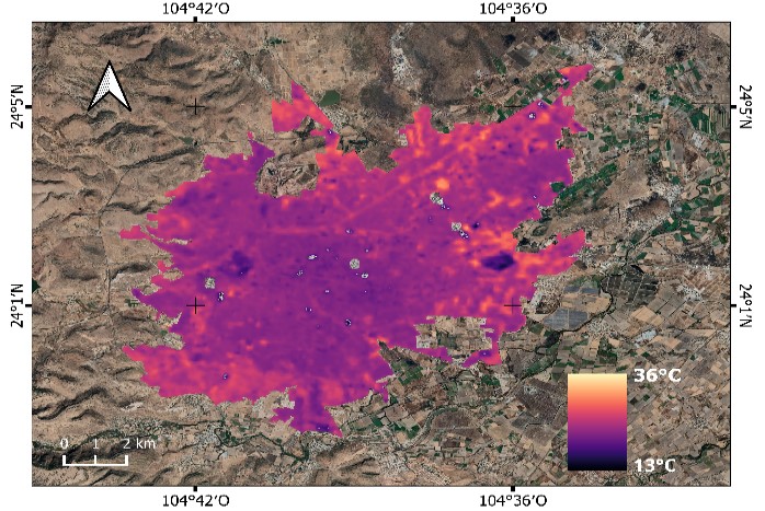
Las áreas verdes de las zonas urbanas contribuyen a la regulación térmica y por lo tanto al confort de la población. El objetivo del presente trabajo fue analizar el efecto de las áreas verdes en la temperatura superficial (TS) registrada mediante sensores remotos en la ciudad de Durango, Durango. Se diferenciaron las áreas verdes públicas y privadas existentes en la ciudad y se calculó la superficie en metros cuadrados por habitante. Se realizó una clasificación por uso de suelo (urbano, cuerpo de agua, suelo desnudo y área verde) con el fin de analizar la TS derivada de imágenes del satélite Landsat 8 y sistemas de información geográfica (QGIS); además, se hizo una comparación de TS en tres tipos de áreas verdes (parques, plazas, jardines y camellones). Se analizó el comportamiento de la TS en dos estaciones del año, en invierno de 2021 y primavera de 2022; a partir de lo cual se identificaron las zonas con mayor incidencia de temperatura en dos periodos. Los resultados indicaron una TS menor en las áreas verdes comparada con el uso de suelo urbano (zonas de concreto, construcción y asfalto), así como una tendencia regulatoria en las áreas verdes de mayor extensión (parques). El producto satelital TS permitió evaluar la temperatura en espacios con vegetación dentro de una zona urbana, y se demuestra que entre mayor es el área verde, más regulación térmica existe en las zonas urbanas.
Descargas
Citas
Amini, S., M. Saber, H. Rabiei-Dastjerdi and S. Homayouni. 2022. Urban land use and land cover change analysis using Random Forest Classification of Landsat Time Series. Remote Sensing 14(11):2654. Doi: 10.3390/rs14112654. DOI: https://doi.org/10.3390/rs14112654
Aram, F., E. Higueras G., E. Solgi and S. Mansournia. 2019. Urban green space cooling effect in cities. Heliyon 5(4):e01339. Doi: 10.1016/j.heliyon.2019.e01339. DOI: https://doi.org/10.1016/j.heliyon.2019.e01339
Balsa-Barreiro, J., A. J. Morales and R. C. Lois-González. 2021. Mapping population dynamics at local scales using spatial networks. Complexity 2021:1-14. Doi: 10.1155/2021/8632086. DOI: https://doi.org/10.1155/2021/8632086
Becker, F. 1987. The impact of spectral emissivity on the measurement of land surface temperature from a satellite. International Journal of Remote Sensing 8(10):1509-1522. Doi: 10.1080/01431168708954793. DOI: https://doi.org/10.1080/01431168708954793
Blancarte S., R. H. 2016. La relación entre las áreas verdes y la calidad de vida en ambientes urbanos. Tesis de Maestría en Gestión Ambiental. Centro Interdisciplinario de Investigación para el Desarrollo Integral Regional (CIIDIR), Instituto Politécnico Nacional. Durango, Dgo., México. 113 p.
Callejas, I. J. A., A. Santana de O., F. M. de Moura S., L. C. Durante, M. C. de J. Albuquerque N. and P. Zeilhofer. 2011. Relationship between land use/cover and surface temperatures in the urban agglomeration of Cuiabá-Várzea Grande, Central Brazil. Journal of Applied Remote Sensing 5(1):569-573. Doi: 10.1117/1.3666044. DOI: https://doi.org/10.1117/1.3666044
Castro-Mendoza, I., J. R. Valdez-Lazalde, G. Donovan, T. Martínez-Trinidad, F. O. Plascencia-Escalante and W. Vázquez-Morales. 2022. Does land-use affect the temperature distribution across the city of Tuxtla Gutiérrez, Chiapas, México? Investigaciones Geográficas (107):1-19. Doi: 10.14350/rig.60394. DOI: https://doi.org/10.14350/rig.60394
Chávez, P. S. 1988. An improved dark-object subtraction technique for atmospheric scattering correction of multispectral data. Remote Sensing of Environment 24(3):459-479. Doi: 10.1016/0034-4257(88)90019-3. DOI: https://doi.org/10.1016/0034-4257(88)90019-3
Cilliers, S., J. Cilliers, R. Lubbe and S. Siebert. 2013. Ecosystem services of urban green spaces in African countries—perspectives and challenges. Urban Ecosystems 16:681-702. Doi: 10.1007/s11252-012-0254-3. DOI: https://doi.org/10.1007/s11252-012-0254-3
Congalton, R. G. and K. Green. 2008. Assessing the accuracy of remotely sensed data. Principles and practices. CRC Press. Boca Raton, FL, United States of America. 183 p. DOI: https://doi.org/10.1201/9781420055139
Doraiswamy, P. C. and D. R. Thompson. 1982. A crop moisture stress index for large areas and its application in the prediction of spring wheat phenology. Agricultural Meteorology 27(1-2):1-15. Doi: 10.1016/0002-1571(82)90014-0. DOI: https://doi.org/10.1016/0002-1571(82)90014-0
Food and Agriculture Organization of the United Nations (FAO). 2023. Servicios ecosistémicos y biodiversidad. https://www.fao.org/ecosystem-services-biodiversity/background/regulatingservices/es/. (17 de mayo de 2023).
Ghosh, S. and A. Das. 2018. Modelling urban cooling island impact of green space and water bodies on surface urban heat island in a continuously developing urban area. Modeling Earth Systems and Environment 4:501-515. Doi: 10.1007/s40808-018-0456-7. DOI: https://doi.org/10.1007/s40808-018-0456-7
Green Urban Data (GUD). 2019. Temperatura superficial terrestre ¿afecta mi ciudad? https://www.greenurbandata.com/2019/02/20/temperatura-superficial. (14 de marzo de 2023).
Hossain, M. D. and D. Chen. 2019. Segmentation for Object-Based Image Analysis (OBIA): A review of algorithms and challenges from remote sensing perspective. ISPRS Journal of Photogrammetry and Remote Sensing (150):115-134. Doi: 10.1016/j.isprsjprs.2019.02.009. DOI: https://doi.org/10.1016/j.isprsjprs.2019.02.009
Instituto de Evaluación de Políticas Públicas del Estado de Durango (Inevap). 2021. Programa anual de evaluación 2021. Evaluación específica. Programa de crecimiento verde, incluyente, sostenible y sustentable, municipio de Durango. Inevap. Durango, Dgo., México. 116 p. https://implandgo.gob.mx/IMPLAN/Sistema%20de%20Evaluaci%C3%B3n%20del%20Desempe%C3%B1o/Informe%20Final%20Programa%20Crecimiento%20Verde%202021.pdf. (7 de septiembre de 2023).
Instituto Nacional de Estadística y Geografia (Inegi). 2018. Directorio Estadístico Nacional de Unidades Económicas 2018. Información para la actualización e incorporación de unidades económicas al DENUE. Datos a noviembre de 2018 (DENUE-2018). https://www.inegi.org.mx/rnm/index.php/catalog/341/data-dictionary. (15 de marzo de 2023).
Instituto Nacional de Estadística y Geografía (Inegi). 2022. Aspectos geográficos, Durango. Inegi. Aguascalientes, Ags., México. 44 p. https://www.inegi.org.mx/contenidos/app/areasgeograficas/resumen/resumen_10.pdf. (15 de marzo de 2023).
Instituto Nacional de Estadística, Geografía e Informática (INEGI). 2005. Cartografía Geoestadística Urbana 2005. Durango. INEGI. https://www.inegi.org.mx/app/mapas/?t=7100000000000000&tg=3604. (6 de septiembre de 2023).
Jabbar, M., M. M. Yusoff and A. Shafie. 2022. Assessing the role of urban green spaces for human well-being: a systematic review. GeoJournal 87:4405-4423. Doi: 10.1007/s10708-021-10474-7. DOI: https://doi.org/10.1007/s10708-021-10474-7
Javadi, R. and N. Nasrollahi. 2021. Urban green space and health: The role of thermal comfort on the health benefits from the urban green space; a review study. Building and Environment 202:108039. Doi: 10.1016/j.buildenv.2021.108039. DOI: https://doi.org/10.1016/j.buildenv.2021.108039
Konijnendijk, C. 2021. The 3-30-300 rule for urban forestry and greener cities. Biophilic Cities Journal 4(2):1-2. https://static1.squarespace.com/static/5bbd32d6e66669016a6af7e2/t/6101ce2b17dc51553827d644/1627508274716/330300+Rule+Preprint_7-29-21.pdf. (5 de septiembre de 2023).
Kurbán, A., A. Papparelli, M. Cúnsulo, E. Montilla y E. Ríos. 2007. Espacios verdes y variación de la humedad relativa en entornos urbanos áridos. In: Saravia, L., R. Echazú, R. Abalone, R. Caso, … y M. Tamasi (Comps.). XXX Congreso de la Asociación Argentina de Energías Renovables y Medio Ambiente (Asades). Asades. San Luis, D, Argentina. pp. 1-6. http://sedici.unlp.edu.ar/bitstream/handle/10915/94022/Documento_completo.pdf?sequence=1. (6 de mayo de 2023).
Kwok, R. 2018. Ecology’s remote-sensing revolution. Nature 556:137-138. https://www.nature.com/articles/d41586-018-03924-9. (5 de septiembre de 2023). DOI: https://doi.org/10.1038/d41586-018-03924-9
Liaw, A. and M. Wiener. 2002. Classification and Regression by randomForest. R News 2-3:18-22. https://cogns.northwestern.edu/cbmg/LiawAndWiener2002.pdf. (5 de septiembre de 2023).
Liu, C., P. Frazier and L. Kumar. 2007. Comparative assessment of the measures of thematic classification accuracy. Remote Sensing of Environment 107(4):606-616. Doi: 10.1016/j.rse.2006.10.010. DOI: https://doi.org/10.1016/j.rse.2006.10.010
López G., F. M, L. A. Navarro N., R. E. Díaz C. y J. Navarro-Estupiñán. 2021. Cobertura vegetal y la distribución de islas de calor/oasis urbanos en Hermosillo, Sonora. Frontera Norte 33:1-32. Doi: 10.33679/rfn.v1i1.2088. DOI: https://doi.org/10.33679/rfn.v1i1.2088
López-Serrano, P. M., J. J. Corral-Rivas, R. A. Díaz-Varela, J. G. Álvarez-González and C. A. López-Sánchez. 2016. Evaluation of radiometric and atmospheric correction algorithms for aboveground forest biomass estimation using Landsat 5 TM data. Remote Sensing 8(5):369. Doi: 10.3390/rs8050369. DOI: https://doi.org/10.3390/rs8050369
McFeeters, S. K. 1996. The use of the Normalized Difference Water Index (NDWI) in the delineation of open water features. International Journal of Remote Sensing 17(7):1425-1432. Doi: 10.1080/01431169608948714. DOI: https://doi.org/10.1080/01431169608948714
Meyers, J., A. Langston, D. Devereux and B. Lin. 2020. Mapping land surface temperatures and heat-health vulnerability in Darwin. Commonwealth Scientific and Industrial Research Organisation (CSIRO). Canberra, ACT, Commonwealth of Australia. https://research.csiro.au/darwinlivinglab/wp-content/uploads/sites/278/2020/12/CSIRO_Mapping_LST__Heat_Health_Vulnerability_In_Darwin_Final.pdf. (28 de septiembre de 2023).
Organización de las Naciones Unidas (ONU). 2020. Día Mundial de las Ciudades: Las comunidades son la raíz de las urbes sostenibles. https://news.un.org/es/story/2020/10/1483282. (3 de marzo de 2023).
Programa de las Naciones Unidas para el Medio Ambiente (PNUMA). 2011. Informe Anual 2010. Síntesis del año. PNUMA. Nairobi, KE, Kenia. 124 p. https://www.iri.edu.ar/publicaciones_iri/anuario/cd_anuario_2011/Mayd/Programa%20de%20las%20Naciones%20Unidas%20para%20el%20Medio%20Ambiente%20-%20Informe%202010.pdf. (28 de septiembre de 2023).
QGIS Development Team. 2020. Geographic Information System version 3.14. Open Source Geospatial Foundation Project. http://qgis.osgeo.org. (26 de enero de 2020).
Qiu, G. Y., H. Y. Li, Q. T. Zhang, W. Chen, X. J. Liang and X. Z. Li. 2013. Effects of evapotranspiration on mitigation of urban temperature by vegetation and urban agriculture. Journal of Integrative Agriculture 12(8):1307-1315. Doi: 10.1016/S2095-3119(13)60543-2. DOI: https://doi.org/10.1016/S2095-3119(13)60543-2
Rendón G., R. E. 2010. Espacios verdes públicos y calidad de vida. In: Centre de Política de Sòl i Valoracions y Universidad Autónoma de Baja California (Edits.). Memorias del 6o Congreso Internacional Ciudad y Territorio Virtual. Centre de Política de Sòl i Valoracions y Universidad Autónoma de Baja California. Mexicali, BC, México. pp. 1-14. https://upcommons.upc.edu/handle/2099/12860. (14 de marzo de 2023).
Romero B., R. 2017. Lima tiene un déficit de 56 millones de metros cuadrados de áreas verdes. https://rpp.pe/politica/actualidad/lima-tiene-un-deficit-de-61-millones-de-metros-cuadrados-en-areas-verdes-noticia-1021931. (6 de septiembre de 2023).
Rouse, J. W., R. H. Haas, J. A. Schell and D. W. Deering. 1974. Monitoring vegetation systems in the Great Plains with ERTS. In: Freden, C. S. and E. P. Mercanti (Edits.). Proceedings of the Third ERTS-1 Symposium. National Aeronautics and Space Administration. Washington, DC, United States of America. pp. 309-317.
Sarricolea E., P. y H. Romero A. 2010. Análisis de los factores condicionantes sobre las temperaturas de emisión superficial en el área metropolitana de Valparaíso, Chile. ACE: Architecture, City and Environment 5(14):79-96. Doi: 10.5821/ace.v5i14.2507. DOI: https://doi.org/10.5821/ace.v5i14.2507
Soto-Soto, J. E., J. Garzón-Barrero y G. Jiménez-Cleves. 2020. Análisis de islas de calor urbano usando imágenes Landsat: caso de estudio Armenia-Colombia 1996-2018. Revista Espacios 41(8):9. https://www.revistaespacios.com/a20v41n08/a20v41n08p09.pdf. (5 de septiembre de 2023).
Ullah, S., K. Ahmad, R. U. Sajjad, A. M. Abbasi, A. Nazeer and A. A. Tahir. 2019. Analysis and simulation of land cover changes and their impacts on land surface temperature in a lower Himalayan region. Journal of Environmental Management 245:348-357. Doi: 10.1016/j.jenvman.2019.05.063. DOI: https://doi.org/10.1016/j.jenvman.2019.05.063
United States Geological Survey (USGS). 2017. Landsat 8. Discover the science that our satellites bring to you. https://geonarrative.usgs.gov/landsat-8/. (14 de marzo de 2023).
Villalba M., J. C. 2017. Las áreas verdes urbanas y su relación con la infiltración de agua al subsuelo como servicio ambiental en Xalapa, Veracruz. Tesis de Maestría en Desarrollo Regional Sustentable. El Colegio de Veracruz. Xalapa de Enríquez, Ver., México. 111 p.
World Health Organization (WHO). 2012. Health indicators of sustainable cities in the context of the Rio+20. UN Conference on Sustainable Development. https://www.who.int/docs/default-source/environment-climate-change-and-health/sustainable-development-indicator-cities.pdf?sfvrsn=c005156b_2. (6 de septiembre de 2023).
Descargas
Publicado
Cómo citar
Número
Sección
Licencia
Derechos de autor 2024 Revista Mexicana de Ciencias Forestales

Esta obra está bajo una licencia internacional Creative Commons Atribución-NoComercial 4.0.
Los autores que publiquen en la Revista Mexicana de Ciencias Forestales aceptan las siguientes condiciones:
De acuerdo con la legislación de derechos de autor, la Revista Mexicana de Ciencias Forestales reconoce y respeta el derecho moral de los autores, así como la titularidad del derecho patrimonial, el cual será cedido a la revista para su difusión en acceso abierto.
Todos los textos publicados por la Revista Mexicana de Ciencias Forestales –sin excepción– se distribuyen amparados bajo la licenciaCreative Commons 4.0 Atribución-No Comercial (CC BY-NC 4.0 Internacional), que permite a terceros utilizar lo publicado siempre que mencionen la autoría del trabajo y a la primera publicación en esta revista. (no permite el uso comercial)
Los autores pueden realizar otros acuerdos contractuales independientes y adicionales para la distribución no exclusiva de la versión del artículo publicado en la Revista Mexicana de Ciencias Forestales (por ejemplo, incluirlo en un repositorio institucional o darlo a conocer en otros medios en papel o electrónicos) siempre que indique clara y explícitamente que el trabajo se publicó por primera vez en la Revista Mexicana de Ciencias Forestales.
Para todo lo anterior, los autores deben remitir el formato de carta-cesión de la propiedad de los derechos de la primera publicación debidamente requisitado y firmado por los autores/as. Este formato debe ser remitido en archivo PDF al correo: editorial.forestal@inifap.gob.mx
Esta obra está bajo una licencia de Creative Commons Reconocimiento-No Comercial 4.0 Internacional.